Showing posts with label 18th Century. Show all posts

Monday, August 13, 2018

Hand-Drawn Maps of the Battle of Quebec

The Canadian Broadcasting Corporation (CBC) has a great story about one of the treasures of the Canadian War Museum in Ottawa.

The story explains that the Museum holds in its archives hand-drawn battle-maps, made by the British Army after their victory on the Plains of Abraham in 1759. A great video, explaining the map and some of its details can be found in the article linked to above.

In short, the maps were probably drawn as a report from the British Army back to London about the events of the battle. Such post-action maps were, apparently, typical. This one, shows the site of Quebec City including some features which are still present, such as the walls of the city. The map also shows the location of the various French and British armies at the battle and how they were arrayed to fight.

I had a hard time finding quality images of these maps anywhere, so the ones below are screen-caps taken from the CBC video and website.


This image, which for some reason is somewhat dark, shows a partially zoomed in image of the map. You can see the British formations in red and the French in blue. You can also make out geographic features like hills, and the formidable cliffs the British had to climb for their attack. The walls of the Citadel of Quebec can be seen in the east and a number of roads, some of which remain in use today. 


Here is a more zoomed out image of the same map shown above. It shows a legend, but the image is too low quality to read it. 


This image above is a close-up of the image of the armies lined up for battle.

One of the details that seems most interesting about this map is that it was donated to the Museum anonymously. Who had such a fascinating historic document in their possession for all those years without anybody knowing--such that the donor could be anonymous?

From what I can tell, the maps--which are hugely significant in Canadian history--are gorgeous, but they are not on display for the public. Apparently, they are too fragile and so remain a hidden treasure of the Museum. Alas...


Wednesday, May 16, 2018

18th Century Bellin showing the St. Lawrence River

With a hat-tip to the Map Room Blog I wanted to just write a short bit about a gorgeous map that they wrote about. It's an 18th Century Bellin showing the St. Lawrence River on three sheets. Here they are:


These are gorgeous maps, and can all be viewed in greater detail here.

I don't have much information beyond what the Map Room has provided as to information on the provenance of these maps. I'll content myself with pointing out a few little details that I enjoy.

I always love depictions of Montreal. Here, the island is named with just the settlement of Ville Marie shown. The city of Laval does not appear on the map, with only the name of Isle Jesus. Many of Montreal's suburbs are named here, including Longueil and Boucherville.


Quebec, the modern province through which the river flows, and the city it flows past is inconsistently named. In some places it's spelled the modern way: Quebec, in others, including the map title, it's Quebek. I'm not sure what accounts for this difference.


There are some great place names on this map. Two that stand out to me: Pot à l'Eau-de-Vie (Brandy Pot) and Mille Vaches (a Thousand Cows).


This is a gorgeous map with historic significance and it's clear why it belongs in Quebec's archives. Looking at it though, I am reminded of this other great map of the St. Lawrence, probably made just a few years later. It's hard to say which I like more. It's also interesting to compare these Bellin maps to this collection of other maps of his of the same region. the comparison in level of detail and focus is interesting.

Thursday, May 10, 2018

Add it to the Wishlist: 1766 Map Showing Russian Discoveries of the West Coast of North America

At the time of my writing this post, I am planning a work-trip to Portland, Oregon. Naturally this got me thinking about maps of the region and I decided to see if I could find another west-coast of North America map to add to my virtual wishlist. I got some great ideas from a tweet from Vetus Carta (@rare_maps), an online, Ottawa-based, antique map dealer (as always, no affiliation).

Anyway, the tweet led me to the Vetus Carta site where this gorgeous 1766 of eastern Russia and western North America is on sale.

Nouvelle Carte Des Decouvertes Faites par Des Vaisseaux Russiens Aux Cotes Inconnues De L'Amerique Septentrionale Avec Les Pais Adiacents ('New Map of Discoveries Made by Russian Vessels on the Unknown Coasts of North America with Adjacent Countries') published in Amsterdam in 1758 by Gerhard Friedrich Müller.

The image above is from Barry Lawrence Ruderman, where the image is available to zoom into in high-quality (and where it's on sale as well). Vetus Carta, though, provides an impressively detailed overview of the map, which, by the way, is properly titled Nouvelle Carte Des Decouvertes Faites par Des Vaisseaux Russiens Aux Cotes Inconnues De L'Amerique Septentrionale Avec Les Pais Adiacents ('New Map of Discoveries Made by Russian Vessels on the Unknown Coasts of North America with Adjacent Countries') published in Amsterdam in 1758 by Gerhard Friedrich Müller.

Anyone interested in the finer details of the map's history should visit the Vetus Carta site. From my perspective, one of the most important points of this history is that this map not only went on to inspire many other, contemporary map-makers, but that it helped to debunk some of the popular, though incorrect thinking about the region at the time. It was a groundbreaking map in that it was more scientific than other maps of the region that were already available.

Vetus Carta goes on to note some of the inaccuracies in this map, which, again, was more accurate than most of what was already out there: first, it shows a “River of the West” at the “entrance discovered by Martin d’Aguilar in 1609.” This river, which supposedly ran from Hudson's Bay to the Pacific, is a figment of someones imagination. There is also a supposed entrance into the continent that the map-maker says was discovered by Juan de Fuca in 1576, this is incorrect as well. There's also the incorrect shape of Alaska.

From my perspective, as a layperson who really enjoys these antique maps, there are some different things that have caused me to add it to my wishlist other than its historic significance.

Nouvelle Carte Des Decouvertes Faites par Des Vaisseaux Russiens Aux Cotes Inconnues De L'Amerique Septentrionale Avec Les Pais Adiacents ('New Map of Discoveries Made by Russian Vessels on the Unknown Coasts of North America with Adjacent Countries') published in Amsterdam in 1758 by Gerhard Friedrich Müller.

I love the blanks on this map. Its amazing to think of a time when people looked at vast spaces of the world and said "we have no idea what's there". Of course, someone knew what was there, but the Russians who provided the information for this map, did not, and so we're left with an enormously large void whose contents could have been anything. For similar reasons, I love the inaccuracies in northern Quebec and around Hudson's Bay.

Nouvelle Carte Des Decouvertes Faites par Des Vaisseaux Russiens Aux Cotes Inconnues De L'Amerique Septentrionale Avec Les Pais Adiacents ('New Map of Discoveries Made by Russian Vessels on the Unknown Coasts of North America with Adjacent Countries') published in Amsterdam in 1758 by Gerhard Friedrich Müller.

I also love the contrast in this map between the detailed Russian territory which appears to be a place that was known to European map makers on the one hand, and the supposed emptiness of North America on the other. The places seem so tantalizingly close to one another, and yet, the people living in the east, who knew their own lands, knew nothing of the west or the people in it.

Nouvelle Carte Des Decouvertes Faites par Des Vaisseaux Russiens Aux Cotes Inconnues De L'Amerique Septentrionale Avec Les Pais Adiacents ('New Map of Discoveries Made by Russian Vessels on the Unknown Coasts of North America with Adjacent Countries') published in Amsterdam in 1758 by Gerhard Friedrich Müller.

Some of the annotations on this map are also wonderful. The indications of the voyages of Russian explorers are fascinating historic details, but comments like the one above are just great. It reads: 'Land about which we have claims from residents of Kamchatka, some of whom say that it can be seen from Bering Island'. This is just more reinforcement of how close the land of the map-maker is to the land about which he knows nothing, and how tempting such a place may be for an explorer.

This is really a great map, and one that I'd love to have if I could ever afford such wonderful things. Until then, I can enjoy it as part of my virtual wish-list collection.

Wednesday, April 11, 2018

Add it to the Wishlist: Tobias Conrad Lotter Map of Galicia and Lodomeria ca. 1775

My maps tend to be of places I've visited. I would make an exception for this one, because though I've never been to this place, my ancestors knew it well.

This is a map of Galicia, parts of what today are in Poland and Ukraine, but at the time of this map, were parts of a kingdom under Austrian, Hapsburg rule.

Here's the map, it's held by the New York Public Library, and I'm not sure that any copies of it exist on the market for a collector to aquire.

Tobias Conrad Lotter Map of Galicia and Lodomeria ca. 1775 covering current parts of Poland and Ukraine

I found the map on this website, which allows you to zoom in and really explore it, and also provides some good detail on it. The map is undated, and it's estimated that it was made between 1772 and 1810. It's assumed, however, that it was published during the lifetime of the map-maker, Lotter, which would place it around 1775.

I've always kept an eye out for a map that showed the town I've heard stories about from my only grandparent not to be born in Canada. The town she was born in was alternately called Javorov, Jawrow, or today Yavoriv, where there is a NATO training facility and which is in Ukraine, near the Polish border. The nearest big city, which is the one where it sounds like members of my family traveled frequently for business is Lemberg, known today as L'viv, also in Ukraine.

Tobias Conrad Lotter Map of Galicia and Lodomeria ca. 1775 covering current parts of Poland and Ukraine

Based on this map, and its legend, Jaworow was an ordinary town along a postal route and seems to have had a post office.

Tobias Conrad Lotter Map of Galicia and Lodomeria ca. 1775 covering current parts of Poland and Ukraine

The map is a true historical snapshot. The kingdom of Galicia no longer exists. Instead of being within Poland, the town of Yavoriv now lies within Ukraine. If you have the stomach, you can also read this nearly contemporary account of what befell the Jews of the town during the Holocaust (incidentally, also from the New York Public Library). Relatives of my grandmother are listed among the murdered from that town.


Monday, April 9, 2018

1764 Bellin map of Santa Marta, Colombia

My wife and I took our honeymoon in Cartagena, Colombia. I really wanted to try to find an antique map of the city before I left, but had a hard time locating anyone who had any selection to sell.

We found one antique dealer who had literally one antique map. It was not of Cartagena, so that one is still on the wishlist, but I did get my hands on something great. Behold my 1764 Bellin map of Santa Marta, Colombia.

1764 Bellin Map of Santa Marta or Sainte Marthe Colombia

As always, David Rumsey has a better zoomable version, and I note as well that the map is held in the collection of the National Library of Colombia.

I don't know too much about Colombia's history, and almost didn't buy the map because I had never heard of Santa Marta--Sainte Marthe on the map--had not visited it, and didn't want a map of a place that meant nothing to me. The seller told me a bit about the town and then, I had to have the map.

Santa Marta was the first Spanish colonial city in Colombia. It's also the oldest surviving city in that country and the second oldest in all of South America. It was founded in 1525, contrast that with the first attempt at founding Quebec City in 1535.

The map is also a Bellin. Many map collectors and historians, recognize Bellin as an important cartographer, producing a wide range of high quality maps in France in the mid to late 18th Century. That was another hook for me, as well as the map's age. This one was produced in 1764.

There are a few elements of the map that make it visually quite interesting. For one, at a glance, I find it looks as though the ocean is to the right of the town, when clearly, it's to the left, in the west. One reason I think my mind plays this trick is the contours around the hill make it seem to be an island.

I also really like the depictions of the small forts and "castles" along the coast. They are not given too much detail by Bellin, but are an attractive feature of the map.


Though it's not from a place I've been, this map is still of historic significance, and makes a souvenir of the adventures we went through, off the tourist path, to find and buy it. I'm proud that it's in my collection!

Thursday, March 29, 2018

First Nation's Mapping of Canada: Ochagach's 1730 Map

I wrote about an amazing 1762 map of Canada I found online. One of the things that fascinated me about that map, was a reference it had to Ochagach. Ochagach was a Cree "Indian" or First Nations person who drew a map to the west coast for La Vérendrye, the French explorer and fur trader.

There's a short bio of Ochagach here. As the bio explains, the route he proposed became essentially a crucial highway to the western parts of Canada used by fur traders. In the French context, it was the fur trade and desire for pelts that drive not only exploration, but settlement and expansion and shaped North America.

Ochagach's map is fascinating to look at and is available in "zoomable" form.


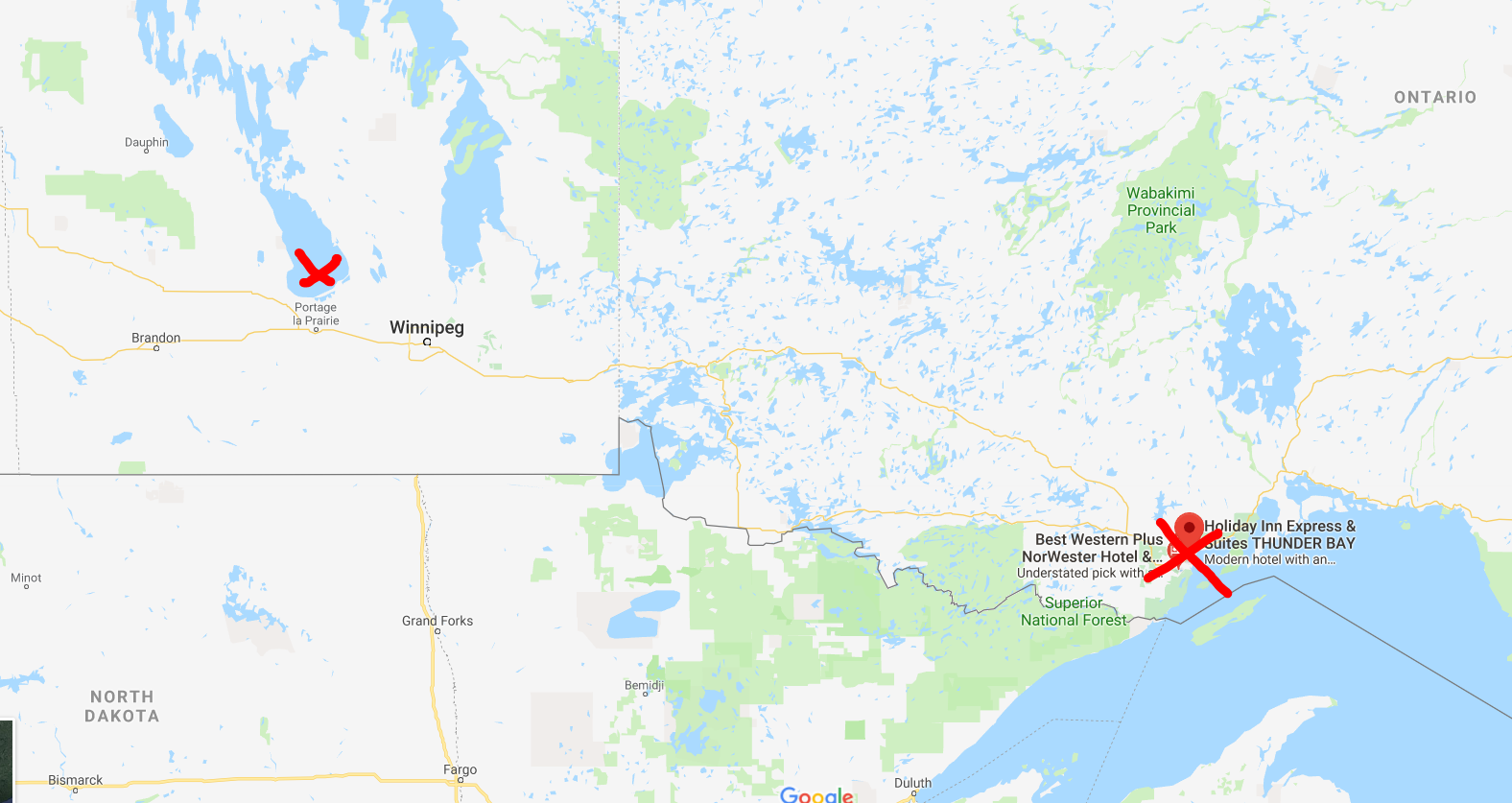
Remember, the first nations of Canada, as far as I know, had no written language or tradition of map-making. This was a person, who from his own mind, was able to prepare a map of Canada beginning at modern day Thunder Bay, Ontario and ending up somewhere beyond Lake Winnipeg, Manitoba. Today, that would be a car ride of over 1,000 KM.


Approximate start and finish points of the original route
This is quite a vast distance that Ochagach had good knowledge of, at a time when choices for transportation were a canoe or walking. 

The map shows what appear to be a series of lakes, connected by either short rivers or portages leading ultimately to lake "Ouinipigon" which could be either modern lake Winnipeg or lake Winnipegosis. The various lakes along the route are numbered. I don't know enough about the map to know if these are numbered to help a traveller count how far along they are, or whether it refers to the number of days it takes to reach a certain point.


I've seen the map  compared to the map for a subway system in that distances are somewhat reduced and the point of the map is to show a destination and tells you not very much about what goes on between the destinations. In this case, the subway "stops" seem to be the various lakes that you have to count off and traverse to get to where you're going.

There are some fascinating annotations on the map in French that are worth a closer look at. 

First, there are details like the ones in this image. Where there is a rare name given to a lake, as opposed to just a number, with an interesting annotation in French: "Lake of Tecacamcouey, of three days of walking". Basically, this map is explaining how long a portage needs to be made to get to this lake.


The image with the name of the destination lake, "Ouinipigon" is also shown with a similar annotation about three days of walking. This image also notes where the Assinibois people live, and says that the map was sketched by the "Cris" or Cree people.


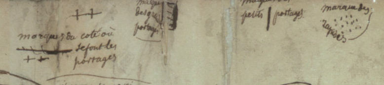
Finally, this image shows the legend of the map. Crosses represent portages. A number of horizontal lines represent large portages, a single vertical line is a short portage and dots are rapids.


There is an interesting, and short article here, in French, about First Nation's cartography. One of the more interesting points it makes, is just how influential First Nations, in general, and Ochagach in particular, was to European map makers. The article cites Ochagach's map as being the necessary information needed by both Philippe Buache and Bellin to complete their maps (images below from Barry Lawrence Ruderman). The influence is clear from just a glance.


Bellin. The annotation in the top left reads, in French "We do not know if in these parts there is land or water"

Buache

Thursday, March 22, 2018

The Puzzle of the Map: Seven Bridges of Königsberg (today Kaliningrad)

I'm bad at math. Like, really bad. This is hard on my father who is a mathematician with the degrees to prove it. He keeps trying to get me interested in math, and his latest attempt is to tell me about the problem of the seven bridges of Königsberg, today Kaliningrad, Russia.

Here's the issue, and a colourful 1732 map of the city available for purchase here (as always no affiliation between me and the seller of any kind, simply giving credit where it's due), to help illustrate it.


As you can see, the city in 1732 had seven bridges, which I've highlighted in yellow. Residents used to like to play a game. They would try to take a stroll around the town attempting to cross each bridge exactly once and start and end in the same spot.

This is the point where you may want to take out a piece of paper and try to sketch this out on your own. 

Meanwhile, I can also show you this fabulous map of the city from sometime in the 1580's before the city's seventh bridge was built. This map is no longer for sale, as it was sold by Sanderus Antiquariat, as you can see here. It looks like if there were a seventh bridge on this map, it would be obscured by the couple standing in the foreground. 


WARNING

SPOILERS FROM HERE ON

One of the wonderful things about the beautiful map above, is that having six, instead of seven bridges, is basically the only way it would be (sort of) possible to accomplish this bridge-walking map puzzle. It's impossible to do it with seven bridges, and possible with six bridges if you end up somewhere other than where you've started, and this is where the math comes in.

My father suggested I write about this because of the famous mathematician Leonhard Euler. Euler essentially reduced the problem to a graph. Now, this is where my lack of mathematical knowledge shows, but from what I understand, you have to almost forget about the bridges for a moment, and imagine the various points or nodes you'll be going to. Looking at the map above, imagine for example that you start at the church on the central island, you can cross to the south bank of the river, use the other bridge to get you back to the central church, then cross to the north bank, walk along it to get back to the central church, cross to the orchard in the east, and then back up to the north bank.

Like this:


Euler explained that in order for the puzzle to work, each location, point or node (the central church, the north and south bank and the orchard, must have either exactly zero or two points of contact with each other. If there are more, and (I think) especially if it's an odd number, then it doesn't work. 

Anyway, I don't want to pretend to know anything about math, so I'll happy link to a few good sources of information about the puzzle. Here, here and of course, wikipedia, here.

Meanwhile, to soothe your frustration, enjoy these beautiful maps. They're really great.

Thursday, March 15, 2018

Add it to the Wishlist: A Snapshot of North American History from 1762

I notice, as I build up my virtual wish-list, that many of the maps I'm choosing aren't from places I've been, but where I'm from, specifically Montreal, Quebec or Canada. That's why this 1762 map by Thomas Jefferys titled: "A Map of Canada and the North Part of Louisiana with the Adjacent Countrys [sic]" easily makes the list. The map is being offered for sale by Neatline Rare Maps of San Francisco for more money than I could ever hope to be able to afford to spend on a map!

Here's a picture of it:

This 1762 map by Thomas Jefferys titled: "A Map of Canada and the North Part of Louisiana with the Adjacent Countrys [sic] shows eastern Canada including Ontario, Quebec, New Brunswick, Nova Scotia and PEI as well as the great lakes. It has blanks across most of the prairies to the west coast, but does show lake Winnipeg.


I highly recommend visiting the Neatline site to get a much closer zoomable look at this map. Neatline has also provided a well researched background of the map and what it shows.

There are a couple of interesting points Neatline makes that are worth highlighting:

An image of the west coast showing a mythological Chinese voyage to North AmericaThe reference to First Nations groups is interesting, not only in their identification on the map, but also in that part of this map seems to have been made possible by reports from a first nations explorer named Ochagach who himself produced a map useful for western exploration by the French. It's a significant detail that tends to be lost in more general pictures of first nations that we learn about in school.

The other is the map's "mythological" elements. To me, the coolest is the legend of Fou-Sang, shown on the west coast of the map. It's a place supposedly visited by the Chinese as far back as 219 BC. Wikipedia writes a bit more about it. It's a remarkable story, but may have been a popular myth at the time this map was made.

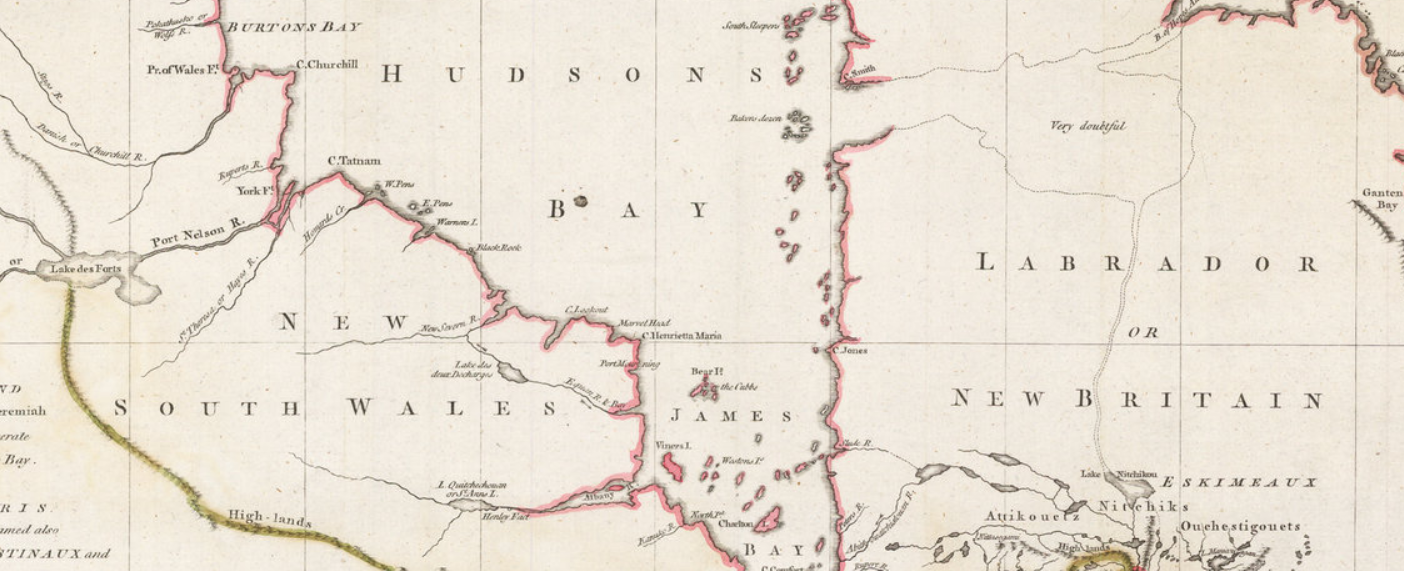
Finally, a few points that Neatline did not mention that are interesting to me, and possibly to most Canadians. For one, there was a New Britain and a New South Wales in Canada. These are not place names that are used today, and are now occupied by other provinces or territories in Canada. I had to do some searching on Wikipedia to learn a bit about their history. Especially interesting was that these place names were in use basically at the same time that Canada was being taken by force by the British from the French. It seems, therefore, that there was some, albeit sparse, English presence north of New France as well as to the south of it.

An image of New South Wales in Canada


I also love the annotation to the east of Hudson's Bay that a supposed lake, which connect to the north Atlantic through Labrador and Northern Quebec was "very doubtful". I wonder why they even thought to put that there. What prompted the map-maker to think this possibly existed?

As a final point, this map gives a great sense of a moment in time in western expansion by the European powers. The eastern portions of the map are detailed, show political boundaries, towns and geological features and looks accurate to the modern viewer. As you look west, however, detail fades, gradually, until the vast blank expanse of the prairies and west coast. It goes to show, once more, that maps like this are historic snapshots.

A detailed portion of the east coast of Canada on the 1762 map


Thursday, March 8, 2018

Wishlist Map: 5 Things About Montreal You Probably Never Knew

Next up on my wishlist: Bellin's Carte de L'Isle De Montreal et de Ses Environs (Map of the Island of Montreal and its Surroundings) from 1744. This map is available for purchase here, from Arader Galleries (who I have no affiliation or relationship with).


It seems typical of Bellin to show geographic features on his map, but to minimize man made elements. According to wikipedia, at the time this map was made, some 22,000 people lived in Montreal, yet the map does not make this obvious.

Here are five awesome facts about Montreal that we can learn from this map that probably all but the most die-hard Montrealers never knew.

1) Lachine was an island: Today Montrealers are familiar with the neighborhood of Lachine and the Lachine canal that borders it. The canal was built to bypass the rapids shown on the map (the "sault"). The Canal, however, was not all a new waterway. Instead, it was an expansion of Lac St. Pierre that was already separating Lachine from the rest of Montreal.

2) Yes, they really called it "La Chine" (China): La Chine, which evolved into the modern Lachine, was originally a derisive nickname. The explorer La Salle believed that China lay just beyond the impassible rapids upstream of Montreal. Of course it didn't, and what he returned to his home in Lachine from his failed efforts to reach China, he and his companions were mockingly called "Chinese".

3) Forts, forts, forts! There were forts all over the island of Montreal. It would be interesting for a real Montreal historian (i.e. not me) to indicate if any of these still exist, but there were lots of them. I see a fort Roland, fort De La Chine, even a fort Pointe Claire: today an important suburb of the city.

4) The island was crisscrossed by streams. This is not obvious in present day Montreal, and some of these have even been filled in. A modern map of the city, especially in the downtown area, shows no sign of some of the waterways on the map in 1744.


Downtown Montreal today. No streams.

5) Windmills. The city was dotted with them, and they help emphasize the rural nature of the city at the time. Windmills would have been an important part of rural life in the 18th century. There are only a handful of these left today, including the one in Pointe Claire. 

Thursday, March 1, 2018

Add it to the Wishlist: 1780 Harrison Antique Map of The St Lawrence River, Canada

I've never seen a map quite like this before.


This is a map of the St. Lawrence river, produced in 1780, and drawn from an earlier map, by a different cartographer, i.e. not Harrison, who published this one. It's featured, and on sale, here.

There's something starkly beautiful about this map. The whole length of the river, diagonally cutting across the map, the lack of any features other than those directly along the water, the blankness of the remainder of the map. It's quite stunning, really.

The map also appeals to me because it features some places I know well, but in a way I've never seen before. They are almost presented without context. Yes there is latitude and longitude, but if you had never heard of the river, or the cities on it, you would have no idea where in the world it was.

Below, I've posted images of some of my favorite features of the map. First though, I did some research on the Duke of Orleans, who commissioned the map off of which this map was based. In 1780, he was a man named Louis Philippe d'Orléans known as le Gros (the Fat). It seems he was a military man, but also, in his later years, a patron of the arts and sciences. Wikipedia lists a number of well known artists and scientists he was close with. Cartographers don't feature in this list, but it would seem reasonable that such a man would have an interest in such things. It would be interesting to hear from someone with more knowledge of this man, or of this map, why the St. Lawrence river, in particular was commissioned.

I also looked up the original map maker. D'anville. It seems that what distinguishes him so much from his contemporaries, is his willingness to leave blank spaces he knew little or less about. This seems to be the case here, but the result is fascinating and magnificent.

Scroll down for some more close-ups of this latest addition to my map wishlist.


The beautiful "Thousand Islands" region in Ontario, on the Canada-U.S. border.

A somewhat distorted view of Montreal. Note St. Anne, on the Island of Montreal. Today a beautiful suburb of the city.

Quebec City, and the mouth of the river. Interesting here is the great detail of smaller tributaries of the river.


Thursday, February 22, 2018

Add it to the Wishlist: Four Gorgeous 1757 Bellin Antique Maps of Canada - Hudsons Bay, St Lawrence River, Quebec City

I'm not a person with much money, so it's easy for me to decide that I can't afford a map I love. If I had the disposable income though, boy would I love this set of four, 18th century maps of Canada on sale by Classical Images, of Melbourne, Australia.

Here there are, four beautiful Bellin maps. I'll present them and what I love about them one at a time.


There's a lot to love about this map of Hudson's Bay. It's an attractive example, the map itself is nice to look at, it has a beautiful cartouche and nice geographic features, like mountains. It's also wonderful in that it seems to have totally made up islands, like "Isle de Bonne Fortune, which does not correspond with anything modern I can find. It also gets the shape of the Bay quite wrong (though James Bay looks pretty good), and Quebec seems to have no Ungava bay in its far north. I also love the note on the far left, in French, about the lands being 'entirely unknown' and a similar annotation at 65 north and 65 west of the 'strait without a name'.


At the time this map of the upper St. Lawrence River and Lake Ontario was made, there was considerable settlement in the colony of New France between the downstream city of Quebec and Montreal. For some reason, from this map, you'd hardly know it. Montreal is on the map, but as an island. There's not much there to speak of a settlement, or the importance of the settlement. The names of rivers appear to be quite detailed--perhaps because rivers were truly the highways of the time--and a number of forts and small settlements are indicated. The drawings of the mountains add to the attractiveness of the map, but points which probably should have been emphasized, are omitted.

Here's the downstream portion of the St. Lawrence. Another attractive map with surprising accurate naming of places like rivers, islands and mountains, but little in the way of cities and towns. A detail of this one, that appears in the others as well, is the identification of the longitude being from Paris, not Greenwich.


This last one may be my favorite, a view of Quebec City, from 1757 during the Seven Years War and while under French rule, before the "Conquest" by the British. In two years time, a battle at the Plains of Abraham (approximate location indicated on the map below), would dramatically alter the course of North American and Canadian history. This map gives wonderful details about the city and seems to make special note of its fortifications. Indeed, the city was very well defended, and it was a series of gambles and good luck that allowed for British success in their assault on the town. One of the most interesting details shown on the map are the walls of the city. Today, Quebec City is the oldest walled city north of Mexico City whose walls still exist.

Approximate location of the British landings at the Plains of Abraham
At the time that these maps of Canada were published, the Seven Years War was already ongoing. It's an amazing thought to imagine the possibility of British, or French officers studying any of these maps to plot strategies, attacks or routes. These maps may not have been practical for military purposes, but at a time when perhaps little was known about these places by rival powers, maps like this may have been the key to successful campaigns.

Monday, January 22, 2018

Add it to the Wishlist: Map of Cartagena, Colombia

My map collecting began as a way to bring home interesting, historical souvenirs from places I travel to. I don't have or seek out maps of countries I have never visited, even if sometimes I have a map of a city I have not been to in that country. That's why this gorgeous map of Cartagena, Colombia makes the wishlist. My wife and I honeymooned in Cartagena, and while there, the only antique map I was able to find was from a nearby Colombian town, but not Cartagena itself.
This is an uncolored version of the map in question

This beauty, however, goes right onto the wishlist.

I noticed the map on twitter, here, as one of the new acquisitions of a New York City based map-dealer Geographicus, rare antique maps. There's plenty of information about the map itself and the cartographer on the Geographicus website, so I don't need to repeat any of that, but I want to point out a few things I love about this circa 1766 map by Dutch cartographer Isaak Tirion.

First, one of my favourite things about any old map is seeing the obvious changes to the place over time. Today, Cartagena feels sprawling, and the undeveloped area on the map labeled Terra Bomba is now a modern, developed area with narrow high rises and hotels, reminiscent in many ways of Miami Beach.
The fortress on the 1766 map named "Kasteel van St. Lazarus" is no longer referred to by that name anymore. It's now the impressive
Castillo de San Felipe de Barajas that my wife and I reached the top of in a sweaty, somewhat miserable hike (it was worth it).

Second, I love the artistic detail of the map. The hills outside the walls being drawn as hills, the beach is clearly a beach, the shores are clearly marshy and vegetated and areas on "Eil Manga" are under cultivation.

I love the detail of the walls surrounding the city, with even the smallest turn or curve appearing on the map, nothing is glossed over.

I also love the identification of the hospital outside the city walls, which I'm guessing was done historically to keep the sick away from the rest of the population. A detail which if true, is a fascinating bit of history enshrined in the map.

Also, item number one on the legend is called, in Dutch "de dom of hoofdkerk" which seems to translate to "the main Church or Cathedral". What's interesting here is that it appears to also show the Palace of the Inquisition, which is across the street, but not named.

I also get a kick out of what seems like a quirky element of the map. The ocean beyond Cartagena is the Atlantic, but this map simply says "the sea". It simply assumes that the viewer knows where in the world the city is, and has no need to name the Atlantic, probably the most important Ocean in the world for the Dutch at the time.

The map is truly gorgeous, and is on the market, only far beyond my means. I have no relationship whatsoever with the seller, but I do hope it finds a good home.