Showing posts with label Quebec. Show all posts

Monday, August 13, 2018

Hand-Drawn Maps of the Battle of Quebec

The Canadian Broadcasting Corporation (CBC) has a great story about one of the treasures of the Canadian War Museum in Ottawa.

The story explains that the Museum holds in its archives hand-drawn battle-maps, made by the British Army after their victory on the Plains of Abraham in 1759. A great video, explaining the map and some of its details can be found in the article linked to above.

In short, the maps were probably drawn as a report from the British Army back to London about the events of the battle. Such post-action maps were, apparently, typical. This one, shows the site of Quebec City including some features which are still present, such as the walls of the city. The map also shows the location of the various French and British armies at the battle and how they were arrayed to fight.

I had a hard time finding quality images of these maps anywhere, so the ones below are screen-caps taken from the CBC video and website.


This image, which for some reason is somewhat dark, shows a partially zoomed in image of the map. You can see the British formations in red and the French in blue. You can also make out geographic features like hills, and the formidable cliffs the British had to climb for their attack. The walls of the Citadel of Quebec can be seen in the east and a number of roads, some of which remain in use today. 


Here is a more zoomed out image of the same map shown above. It shows a legend, but the image is too low quality to read it. 


This image above is a close-up of the image of the armies lined up for battle.

One of the details that seems most interesting about this map is that it was donated to the Museum anonymously. Who had such a fascinating historic document in their possession for all those years without anybody knowing--such that the donor could be anonymous?

From what I can tell, the maps--which are hugely significant in Canadian history--are gorgeous, but they are not on display for the public. Apparently, they are too fragile and so remain a hidden treasure of the Museum. Alas...


Wednesday, May 16, 2018

18th Century Bellin showing the St. Lawrence River

With a hat-tip to the Map Room Blog I wanted to just write a short bit about a gorgeous map that they wrote about. It's an 18th Century Bellin showing the St. Lawrence River on three sheets. Here they are:


These are gorgeous maps, and can all be viewed in greater detail here.

I don't have much information beyond what the Map Room has provided as to information on the provenance of these maps. I'll content myself with pointing out a few little details that I enjoy.

I always love depictions of Montreal. Here, the island is named with just the settlement of Ville Marie shown. The city of Laval does not appear on the map, with only the name of Isle Jesus. Many of Montreal's suburbs are named here, including Longueil and Boucherville.


Quebec, the modern province through which the river flows, and the city it flows past is inconsistently named. In some places it's spelled the modern way: Quebec, in others, including the map title, it's Quebek. I'm not sure what accounts for this difference.


There are some great place names on this map. Two that stand out to me: Pot à l'Eau-de-Vie (Brandy Pot) and Mille Vaches (a Thousand Cows).


This is a gorgeous map with historic significance and it's clear why it belongs in Quebec's archives. Looking at it though, I am reminded of this other great map of the St. Lawrence, probably made just a few years later. It's hard to say which I like more. It's also interesting to compare these Bellin maps to this collection of other maps of his of the same region. the comparison in level of detail and focus is interesting.

Thursday, May 10, 2018

Add it to the Wishlist: 1766 Map Showing Russian Discoveries of the West Coast of North America

At the time of my writing this post, I am planning a work-trip to Portland, Oregon. Naturally this got me thinking about maps of the region and I decided to see if I could find another west-coast of North America map to add to my virtual wishlist. I got some great ideas from a tweet from Vetus Carta (@rare_maps), an online, Ottawa-based, antique map dealer (as always, no affiliation).

Anyway, the tweet led me to the Vetus Carta site where this gorgeous 1766 of eastern Russia and western North America is on sale.

Nouvelle Carte Des Decouvertes Faites par Des Vaisseaux Russiens Aux Cotes Inconnues De L'Amerique Septentrionale Avec Les Pais Adiacents ('New Map of Discoveries Made by Russian Vessels on the Unknown Coasts of North America with Adjacent Countries') published in Amsterdam in 1758 by Gerhard Friedrich Müller.

The image above is from Barry Lawrence Ruderman, where the image is available to zoom into in high-quality (and where it's on sale as well). Vetus Carta, though, provides an impressively detailed overview of the map, which, by the way, is properly titled Nouvelle Carte Des Decouvertes Faites par Des Vaisseaux Russiens Aux Cotes Inconnues De L'Amerique Septentrionale Avec Les Pais Adiacents ('New Map of Discoveries Made by Russian Vessels on the Unknown Coasts of North America with Adjacent Countries') published in Amsterdam in 1758 by Gerhard Friedrich Müller.

Anyone interested in the finer details of the map's history should visit the Vetus Carta site. From my perspective, one of the most important points of this history is that this map not only went on to inspire many other, contemporary map-makers, but that it helped to debunk some of the popular, though incorrect thinking about the region at the time. It was a groundbreaking map in that it was more scientific than other maps of the region that were already available.

Vetus Carta goes on to note some of the inaccuracies in this map, which, again, was more accurate than most of what was already out there: first, it shows a “River of the West” at the “entrance discovered by Martin d’Aguilar in 1609.” This river, which supposedly ran from Hudson's Bay to the Pacific, is a figment of someones imagination. There is also a supposed entrance into the continent that the map-maker says was discovered by Juan de Fuca in 1576, this is incorrect as well. There's also the incorrect shape of Alaska.

From my perspective, as a layperson who really enjoys these antique maps, there are some different things that have caused me to add it to my wishlist other than its historic significance.

Nouvelle Carte Des Decouvertes Faites par Des Vaisseaux Russiens Aux Cotes Inconnues De L'Amerique Septentrionale Avec Les Pais Adiacents ('New Map of Discoveries Made by Russian Vessels on the Unknown Coasts of North America with Adjacent Countries') published in Amsterdam in 1758 by Gerhard Friedrich Müller.

I love the blanks on this map. Its amazing to think of a time when people looked at vast spaces of the world and said "we have no idea what's there". Of course, someone knew what was there, but the Russians who provided the information for this map, did not, and so we're left with an enormously large void whose contents could have been anything. For similar reasons, I love the inaccuracies in northern Quebec and around Hudson's Bay.

Nouvelle Carte Des Decouvertes Faites par Des Vaisseaux Russiens Aux Cotes Inconnues De L'Amerique Septentrionale Avec Les Pais Adiacents ('New Map of Discoveries Made by Russian Vessels on the Unknown Coasts of North America with Adjacent Countries') published in Amsterdam in 1758 by Gerhard Friedrich Müller.

I also love the contrast in this map between the detailed Russian territory which appears to be a place that was known to European map makers on the one hand, and the supposed emptiness of North America on the other. The places seem so tantalizingly close to one another, and yet, the people living in the east, who knew their own lands, knew nothing of the west or the people in it.

Nouvelle Carte Des Decouvertes Faites par Des Vaisseaux Russiens Aux Cotes Inconnues De L'Amerique Septentrionale Avec Les Pais Adiacents ('New Map of Discoveries Made by Russian Vessels on the Unknown Coasts of North America with Adjacent Countries') published in Amsterdam in 1758 by Gerhard Friedrich Müller.

Some of the annotations on this map are also wonderful. The indications of the voyages of Russian explorers are fascinating historic details, but comments like the one above are just great. It reads: 'Land about which we have claims from residents of Kamchatka, some of whom say that it can be seen from Bering Island'. This is just more reinforcement of how close the land of the map-maker is to the land about which he knows nothing, and how tempting such a place may be for an explorer.

This is really a great map, and one that I'd love to have if I could ever afford such wonderful things. Until then, I can enjoy it as part of my virtual wish-list collection.

Thursday, March 15, 2018

Add it to the Wishlist: A Snapshot of North American History from 1762

I notice, as I build up my virtual wish-list, that many of the maps I'm choosing aren't from places I've been, but where I'm from, specifically Montreal, Quebec or Canada. That's why this 1762 map by Thomas Jefferys titled: "A Map of Canada and the North Part of Louisiana with the Adjacent Countrys [sic]" easily makes the list. The map is being offered for sale by Neatline Rare Maps of San Francisco for more money than I could ever hope to be able to afford to spend on a map!

Here's a picture of it:

This 1762 map by Thomas Jefferys titled: "A Map of Canada and the North Part of Louisiana with the Adjacent Countrys [sic] shows eastern Canada including Ontario, Quebec, New Brunswick, Nova Scotia and PEI as well as the great lakes. It has blanks across most of the prairies to the west coast, but does show lake Winnipeg.


I highly recommend visiting the Neatline site to get a much closer zoomable look at this map. Neatline has also provided a well researched background of the map and what it shows.

There are a couple of interesting points Neatline makes that are worth highlighting:

An image of the west coast showing a mythological Chinese voyage to North AmericaThe reference to First Nations groups is interesting, not only in their identification on the map, but also in that part of this map seems to have been made possible by reports from a first nations explorer named Ochagach who himself produced a map useful for western exploration by the French. It's a significant detail that tends to be lost in more general pictures of first nations that we learn about in school.

The other is the map's "mythological" elements. To me, the coolest is the legend of Fou-Sang, shown on the west coast of the map. It's a place supposedly visited by the Chinese as far back as 219 BC. Wikipedia writes a bit more about it. It's a remarkable story, but may have been a popular myth at the time this map was made.

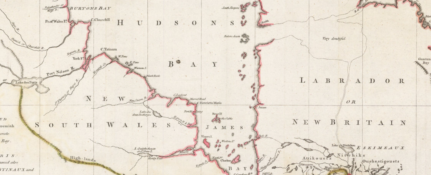
Finally, a few points that Neatline did not mention that are interesting to me, and possibly to most Canadians. For one, there was a New Britain and a New South Wales in Canada. These are not place names that are used today, and are now occupied by other provinces or territories in Canada. I had to do some searching on Wikipedia to learn a bit about their history. Especially interesting was that these place names were in use basically at the same time that Canada was being taken by force by the British from the French. It seems, therefore, that there was some, albeit sparse, English presence north of New France as well as to the south of it.

An image of New South Wales in Canada


I also love the annotation to the east of Hudson's Bay that a supposed lake, which connect to the north Atlantic through Labrador and Northern Quebec was "very doubtful". I wonder why they even thought to put that there. What prompted the map-maker to think this possibly existed?

As a final point, this map gives a great sense of a moment in time in western expansion by the European powers. The eastern portions of the map are detailed, show political boundaries, towns and geological features and looks accurate to the modern viewer. As you look west, however, detail fades, gradually, until the vast blank expanse of the prairies and west coast. It goes to show, once more, that maps like this are historic snapshots.

A detailed portion of the east coast of Canada on the 1762 map


Monday, March 12, 2018

Johnson's Upper and Lower Canada from 1863

There's a lot to love in these two maps of Upper and Lower Canada, parts of modern Ontario and Quebec, respectively as well as New Brunswick and bits of the United States. The maps come from Johnson's Atlas.


This map is an attractive one. It has a nice border, nice coloring (which I assume was done later and is probably not original), and that wonderful quality of spilling outside its borders. The map I have was taken from an atlas, and you can see the different page numbers and how the maps appeared. It's curious to have shown them this way, since the maps present contiguous regions, and it's not obvious why they wouldn't have been oriented differently to show one map that folds in half. This question becomes even more interesting when you consider that the two maps have only one legend, suggesting that they are meant to be viewed together.


The detail on the map is wonderful too. The counties/townships are noted in great detail, even though these sorts of geographic divisions are rarely used in any significant way in Canada these days. The seller of the map noted in the margin that this map is from 1863, which is before Canadian confederation. It is also just before Ottawa became the capital of Canada (1866) and at a time when Quebec City was the capital. Quebec is noted with a red dot on the map.

   The map shows a number of important rail lines, many canals and has three great insets, one of Montreal, one of the important Welland Canal and another of Wolf Island on the border of the United States. Wolf Island is noted as the start of the St. Lawrence river, and the inset shows a charming collection of buildings on the site of the town of Kingston, Upper Canada, a very important town at the time.

The Welland Canal, which was an important shipping route at the time that helped bypass Niagara Falls also gets its own inset, as does Montreal. Montreal's inset does not show much detail about the city, but identifies important towns on the island, shows the, now scenic, Lachine Canal, the historic Grand Trunk Railway, and has good detail about the surrounding region. At the bottom of the image of the Montreal inset, two different meridians are shown, one from Greenwich, and another from Washington.

 It's also interesting that while today Toronto is not only the largest city in Canada, but one of the top 5 in North America, on this map, it does not merit its own inset, though features which are today much less significant do draw that kind of attention from the map-makers.


Thursday, March 8, 2018

Wishlist Map: 5 Things About Montreal You Probably Never Knew

Next up on my wishlist: Bellin's Carte de L'Isle De Montreal et de Ses Environs (Map of the Island of Montreal and its Surroundings) from 1744. This map is available for purchase here, from Arader Galleries (who I have no affiliation or relationship with).


It seems typical of Bellin to show geographic features on his map, but to minimize man made elements. According to wikipedia, at the time this map was made, some 22,000 people lived in Montreal, yet the map does not make this obvious.

Here are five awesome facts about Montreal that we can learn from this map that probably all but the most die-hard Montrealers never knew.

1) Lachine was an island: Today Montrealers are familiar with the neighborhood of Lachine and the Lachine canal that borders it. The canal was built to bypass the rapids shown on the map (the "sault"). The Canal, however, was not all a new waterway. Instead, it was an expansion of Lac St. Pierre that was already separating Lachine from the rest of Montreal.

2) Yes, they really called it "La Chine" (China): La Chine, which evolved into the modern Lachine, was originally a derisive nickname. The explorer La Salle believed that China lay just beyond the impassible rapids upstream of Montreal. Of course it didn't, and what he returned to his home in Lachine from his failed efforts to reach China, he and his companions were mockingly called "Chinese".

3) Forts, forts, forts! There were forts all over the island of Montreal. It would be interesting for a real Montreal historian (i.e. not me) to indicate if any of these still exist, but there were lots of them. I see a fort Roland, fort De La Chine, even a fort Pointe Claire: today an important suburb of the city.

4) The island was crisscrossed by streams. This is not obvious in present day Montreal, and some of these have even been filled in. A modern map of the city, especially in the downtown area, shows no sign of some of the waterways on the map in 1744.


Downtown Montreal today. No streams.

5) Windmills. The city was dotted with them, and they help emphasize the rural nature of the city at the time. Windmills would have been an important part of rural life in the 18th century. There are only a handful of these left today, including the one in Pointe Claire. 

Thursday, March 1, 2018

Add it to the Wishlist: 1780 Harrison Antique Map of The St Lawrence River, Canada

I've never seen a map quite like this before.


This is a map of the St. Lawrence river, produced in 1780, and drawn from an earlier map, by a different cartographer, i.e. not Harrison, who published this one. It's featured, and on sale, here.

There's something starkly beautiful about this map. The whole length of the river, diagonally cutting across the map, the lack of any features other than those directly along the water, the blankness of the remainder of the map. It's quite stunning, really.

The map also appeals to me because it features some places I know well, but in a way I've never seen before. They are almost presented without context. Yes there is latitude and longitude, but if you had never heard of the river, or the cities on it, you would have no idea where in the world it was.

Below, I've posted images of some of my favorite features of the map. First though, I did some research on the Duke of Orleans, who commissioned the map off of which this map was based. In 1780, he was a man named Louis Philippe d'Orléans known as le Gros (the Fat). It seems he was a military man, but also, in his later years, a patron of the arts and sciences. Wikipedia lists a number of well known artists and scientists he was close with. Cartographers don't feature in this list, but it would seem reasonable that such a man would have an interest in such things. It would be interesting to hear from someone with more knowledge of this man, or of this map, why the St. Lawrence river, in particular was commissioned.

I also looked up the original map maker. D'anville. It seems that what distinguishes him so much from his contemporaries, is his willingness to leave blank spaces he knew little or less about. This seems to be the case here, but the result is fascinating and magnificent.

Scroll down for some more close-ups of this latest addition to my map wishlist.


The beautiful "Thousand Islands" region in Ontario, on the Canada-U.S. border.

A somewhat distorted view of Montreal. Note St. Anne, on the Island of Montreal. Today a beautiful suburb of the city.

Quebec City, and the mouth of the river. Interesting here is the great detail of smaller tributaries of the river.


Thursday, February 22, 2018

Add it to the Wishlist: Four Gorgeous 1757 Bellin Antique Maps of Canada - Hudsons Bay, St Lawrence River, Quebec City

I'm not a person with much money, so it's easy for me to decide that I can't afford a map I love. If I had the disposable income though, boy would I love this set of four, 18th century maps of Canada on sale by Classical Images, of Melbourne, Australia.

Here there are, four beautiful Bellin maps. I'll present them and what I love about them one at a time.


There's a lot to love about this map of Hudson's Bay. It's an attractive example, the map itself is nice to look at, it has a beautiful cartouche and nice geographic features, like mountains. It's also wonderful in that it seems to have totally made up islands, like "Isle de Bonne Fortune, which does not correspond with anything modern I can find. It also gets the shape of the Bay quite wrong (though James Bay looks pretty good), and Quebec seems to have no Ungava bay in its far north. I also love the note on the far left, in French, about the lands being 'entirely unknown' and a similar annotation at 65 north and 65 west of the 'strait without a name'.


At the time this map of the upper St. Lawrence River and Lake Ontario was made, there was considerable settlement in the colony of New France between the downstream city of Quebec and Montreal. For some reason, from this map, you'd hardly know it. Montreal is on the map, but as an island. There's not much there to speak of a settlement, or the importance of the settlement. The names of rivers appear to be quite detailed--perhaps because rivers were truly the highways of the time--and a number of forts and small settlements are indicated. The drawings of the mountains add to the attractiveness of the map, but points which probably should have been emphasized, are omitted.

Here's the downstream portion of the St. Lawrence. Another attractive map with surprising accurate naming of places like rivers, islands and mountains, but little in the way of cities and towns. A detail of this one, that appears in the others as well, is the identification of the longitude being from Paris, not Greenwich.


This last one may be my favorite, a view of Quebec City, from 1757 during the Seven Years War and while under French rule, before the "Conquest" by the British. In two years time, a battle at the Plains of Abraham (approximate location indicated on the map below), would dramatically alter the course of North American and Canadian history. This map gives wonderful details about the city and seems to make special note of its fortifications. Indeed, the city was very well defended, and it was a series of gambles and good luck that allowed for British success in their assault on the town. One of the most interesting details shown on the map are the walls of the city. Today, Quebec City is the oldest walled city north of Mexico City whose walls still exist.

Approximate location of the British landings at the Plains of Abraham
At the time that these maps of Canada were published, the Seven Years War was already ongoing. It's an amazing thought to imagine the possibility of British, or French officers studying any of these maps to plot strategies, attacks or routes. These maps may not have been practical for military purposes, but at a time when perhaps little was known about these places by rival powers, maps like this may have been the key to successful campaigns.

Monday, February 19, 2018

Montreal: A Not-So-Old Map of My Hometown and Best City Around!

This 1906 map of Montreal from the Department of the Interior Atlas of Canada is not the most interesting or beautiful to look at, and yet there are so many wonderful things about it. A clearer image may be found here (incidentally, from the same vendor who I think sold it to me).


The source of this map is unique. It's from 1906 and appeared in the first edition of the Atlas of Canada. According to the Canadian government department that still publishes it, that atlas was notable for its emphasis on means of communication and transportation in Canada. 


This is clear from the map. First, the map focuses on the port of Montreal. It's true the city was not as big then as it is now, but the port is impossible to miss. Second, the map notes "street railways" an early form of public transit in the city which is now long gone. Third, larger rail lines are also prominent, including, the famous Grand Trunk Railway, which had its headquarter's in Montreal and was an important rail-line for the country. The Lachine Canal is hard to miss too. Finally, there's the well known Victoria Bridge, shown on the map with a different name.


The bridge shown on this map also alludes to the many changes the city has undergone. For example, today, this view of Montreal would show at least two more bridges from the island, including the now heavily traveled and practically indispensable Jacques Cartier Bridge.

Something else pops up from looking at a current map of Montreal: there are more islands in the St. Lawrence River! "St. Helen Island" and "Ile Ronde" are merged into a single island and there's another landmass just to the east of that. These were all build in preparation for the World's Fair held in Montreal in 1967: Expo '67. The earth dug up in the construction of the Montreal Metro (subway) system was used to expand these islands where the pavilions were based. The U.S. exhibit, Buckminster Fuller's geodesic dome is still on this island. So is La Ronde, an amusement park that takes its name from the once small island that sat alone in the river.

Montrealers will recognize many familiar landmarks on this map, even if they are not named. For example, McGill university is where you would expect to see it, as is the unnamed Royal Victoria Hospital. The train station is also right where you'd expect it.

I had this map framed by an excellent framer, and we discussed where to put the matting. Someone present suggested that the matting should go right to the border of the map, showing only the view of the city and not the plain black line forming the border at the edge. The framer made a comment that has since stuck with me: the cartographer decided that they wanted to only show this part of the city, and nothing else. They chose that location for the border, and to hide it, would be detracting from the historic significance of the document. It reminded me that these maps are bits of history, and to have them, and show them comes with the obligation of being faithful to their purpose and message.


Saturday, December 30, 2017

6 Things That Make Monte's 16th Century Planisphere One of the Coolest Maps

I recently came across this article about a map from 1587 that has so many fascinating elements, it's hard to know where to start, and impossible to imagine someone not being fascinated by it.

1) First, the map is huge. It's comprised of 60 pages which are to be arranged in a circle, adding up to a 10 foot by 10 foot map.

2) Second, the map has a unique perspective, looking at the world from the Arctic down. Indeed, the north pole itself is shown as being covered by some sort of landmass, and Canada's Arctic listed as new, unknown lands.

3) Third, it seems, little is known about the mapmaker himself. A quote from the article:

Historians know some basic details about the cartographer who created the map, Urbano Monte (1544-1613), a nobleman who lived in Milan, in northern Italy. When he was 35, Monte married 18-year-old Margarita Niguarda, and they had four sons and one daughter. Because of his family's status and affluence, Monte didn't have to work. Rather, he spent his time collecting books for his renowned library and pursued scholarly interests...
It's amazing to me to think of this man of great wealth and leisure choosing to pass his time this way, collecting information about the world and embarking on creating such a massive map.  Another fascinating detail is that the mapmaker met with the first ever official Japanese diplomatic mission to Europe. It's wonderful to imagine that scene. In a world where Japanese and Europeans may have been alien to one another, how would they have communicated? What subjects might they have discussed? How would they have regarded one another?

4) Fourth, the mythology of the map is stunning. It's filled with sea creatures, strange beasts and mermaids. Why did the mapmaker include these things? Did he think they were beautiful, was it simply common to have such things on maps, or did a European in the time of the Renaissance truly believe such creatures existed? There are some outstanding images of the map and these creatures here.

5) Fifth, this map takes a political and historic snapshot of the world at the time of its making. It lets us know who the various world leaders are. Tells us about them, shows us where their fleets have reached, all in addition to showing us where their territory extends, not only in lands that were known to Europeans at the time, but also in the Americas, only recently coming under exploration and European settlement.

6) Sixth, and finally, on a personal note, I love how this map depicts some places I know. For example, my home province of Quebec is referred to as the Province of Canada. Quebec City is labeled as Stadacona, it's original name, and my hometown on Montreal is known by its original name, Hochelaga. The Great Lakes do not appear on the map. This awesome site allows you to scroll around and zoom in on the map. I could spend hours...