Showing posts with label Newfoundland. Show all posts

Monday, June 11, 2018

Wearable Maps: Newfoundland

I'm not the type to normally walk around in clothes adorned with maps, but after falling in love with Newfoundland on my first visit there, I could not resist this cool T-shirt map.


One of the things that makes this map so interesting is that it shows the names of some very small towns in Newfoundland. Also, it shows just how sparse the interior is, and how busy the coasts are. The size of the name on the map corresponds to the size of the town itself.

Really though, the best thing about this map, are the fun place names in Newfoundland. Some of which I've actually been to!

For example, on the image below, note Nickey's Nose Cove, Coffee Cove, and Leading Tickles.


Here we have Placentia, Dildo, Little Heart's Ease, and Bonavista, first sited by Cabot.


 Yes, these are all real places, and yes, they're beautiful. Get to Newfoundland, it's wonderful!


Wednesday, April 4, 2018

15th Century Viking Map of Vinland Being Studied by Yale

I recently came across this article about Yale doing an examination of the Vinland Viking map. I had heard about Vinland, but don't recall having heard about this map before. In short, Vinland is an as yet undiscovered location supposedly settled, at least briefly, by the Vikings in the 15th Century, before Columbus reached the New World. This map, which would have been almost as old as the Viking discovery, showed Vinland.

Here is an image of it from Wikipedia.

The probably forged Map of the Viking discovery of Vinland in the possession of Yale University

It's a pretty cool map, and very exciting to have so old a map of the new world. The problem is, it's almost universally considered to be a fake. There is some disagreement on this, but the majority of scholars have dismissed this map as being inauthentic for a number of reasons including the chemical composition of the ink used (it contains substances unused until the 1900s) and the way it was bound into a larger manuscript which would have rendered much of it illegible.

Nonetheless, Yale is putting some serious work into researching this map. They are looking at the topography of the map itself, studying the DNA of the animal skin it was printed on, and examining the maps's chemical composition. It's all very impressive, and still, they don't expect to prove its authenticity. Instead, they're trying to study a document which has become so culturally important, that many atlases feature it even with the notation that it's probably fake.

So then, what is Vinland? The answer is that nobody's quite sure. There are disagreements among experts as to what the word Vinland meant to the Vikings and whether it was a single place, or multiple places. If Vinland does refer to vines, or wine, as some suggest, it means that it must be at least as far south as the south shore of the St. Laurence River, where Jacques Cartier found wild vines. One thing that does seem more certain is that the only actual archaeological evidence of Viking settlement in North America, the site at L'Anse aux Meadows, Newfoundland, is not Vinland.

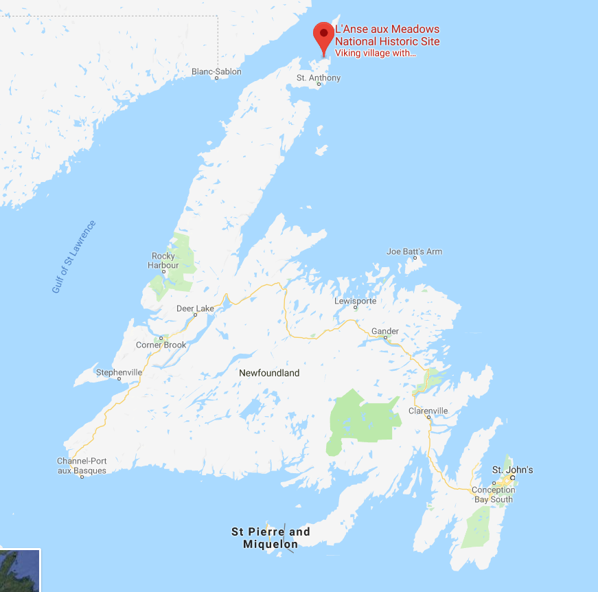
Map of L'Anse aux Meadows, NewfoundlandL'Anse aux Meadows is a remote site at the northernmost point of Newfoundland. Viking artifacts have been found there, as well as building materials from Iceland and Greenland that date to around 1000 C.E. This is conclusive evidence that there were Vikings living in Newfoundland, for at least a short time,  around 500 years before Columbus and any other European reached the area. The site, however, is considered by historians to be a base, or a waypoint for onward exploration. It was probably just a place to stop, maybe repair boats, take on more supplies, and then keep exploring onward. As such, the location of Vinland remains a mystery, and this map will likely not be helpful in finding it.

As an aside, I had the good luck of visiting L'Anse aux Meadows, which is not an easy place to get to, but which is stunningly beautiful and worth the trip. It also has a reconstruction of what the Viking settlement on the spot may have looked like. It's a long trip, but in my view, absolutely worth it. Check out some pictures I took while there.

UNESCO heritage plaque indicating Vikings were at this site.

L'Anse aux Meadows, Newfoundland

Site of a Viking building. The indentations on the ground show the footprint of the long since decayed building.
This depression was the actual site of a Viking structure.

A recreated Viking settlement on the site of the only known one in North America.

A recreated Viking settlement


Fog rolling into L'Anse aux Meadows, Newfoundland

Fog rolling in to L'Anse aux Meadows, Newfoundland


Thursday, January 25, 2018

Come From Away: Colton's New Brunswick, Nova Scotia, Newfoundland and Prince Edward Island

In the Canadian Maritime and Atlantic provinces, someone who's from any place other than one of those four provinces is known as a CFA, a come from away: because that's where you're from, away.

A few years back, my wife and I went on a fabulous road trip through the Maritime and Atlantic provinces (Newfoundland and Labrador is an Atlantic province, not a Maritime one), had an amazing time, met some wonderful people, saw some great sights, ate some great food, got engaged and I bought a couple of maps!

The map I'll feature in this post is a gorgeous Colton, first published in 1855 of New Brunswick, Nova Scotia, Newfoundland and Prince Edward Island. I bought this map at an art gallery in Halifax that also sold some maps called Zwicker's Gallery (a place that is itself an institution). They had some other beautiful maps of the region (Including a great one with images of some dogs this part of the world are famous for, notably the Labrador and the Newfoundland Dog), but this was the only one I could afford at the time.


 I love this map! There's so much about it that's appealing.

First, just look at it! The border is gorgeous. It has that wonderful element of spilling outside the border, showing every element of the land. It breaks up the provinces (colonies at the time) into counties, which I don't believe are particularly significant these days, and it's in excellent condition. Even the name plate of the map is appealing.

The way "Colton" is written, the various fonts of the names of the different places...I just find this map very pleasing to look at.

Second, the history represented on this map is wonderful. Nova Scotia and New Brunswick were among the first four provinces of Canada which came together for confederation in 1867. Prince Edward Island would only join Canada in 1873 (largely because of heavy debt from having built a railroad on the small island), and Newfoundland joined still later, in 1949, after a much debated referendum.

Third, the detail on this map is impressive. So many of the tiny bays, capes and coves on Newfoundland are named. Some of these places may have been, or were being settled for the first time around when this map was published. Other places, including some of Newfoundland's largest communities today are completely absent from the map, in some cases, like Gander, Newfoundland, because they didn't even exist until around 100 years later.


 A final thing I enjoy about this map, is that it presents another mystery to me. The map clearly says it's a Colton. It also says it was first published in 1855. That doesn't mean that the actual paper map I have is from 1855, it could be more recent. There's an annotation from the seller next to the page number (19) that shows the year 1864. The problem is, when I search, I can't find any Colton atlases published that year. Even when I go through the ever-useful Rumsey website, I can find very similar Colton maps, but none that are on page 19. Perhaps even more strange, there is an almost identical Johnson map that is printed on page 19 from 1865, but it is clearly not the same map I have. All I've been able to find is someone selling the identical map (in rough condition) on ebay. This person claims their map is from 1855, but they may simply be looking at the date of first publication, which could be quite different from the date of actual printing. I'm including a screen capture of the item for sale below.

Once more, another mystery to solve. Anyone with thoughts or insights is encouraged to let me know!