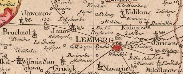
My maps tend to be of places I've visited. I would make an exception for this one, because though I've never been to this place, my ancestors knew it well.
This is a map of Galicia, parts of what today are in Poland and Ukraine, but at the time of this map, were parts of a kingdom under Austrian, Hapsburg rule.
Here's the map, it's held by the New York Public Library, and I'm not sure that any copies of it exist on the market for a collector to aquire.
I found the map on this website, which allows you to zoom in and really explore it, and also provides some good detail on it. The map is undated, and it's estimated that it was made between 1772 and 1810. It's assumed, however, that it was published during the lifetime of the map-maker, Lotter, which would place it around 1775.
I've always kept an eye out for a map that showed the town I've heard stories about from my only grandparent not to be born in Canada. The town she was born in was alternately called Javorov, Jawrow, or today Yavoriv, where there is a NATO training facility and which is in Ukraine, near the Polish border. The nearest big city, which is the one where it sounds like members of my family traveled frequently for business is Lemberg, known today as L'viv, also in Ukraine.
Based on this map, and its legend, Jaworow was an ordinary town along a postal route and seems to have had a post office.
The map is a true historical snapshot. The kingdom of Galicia no longer exists. Instead of being within Poland, the town of Yavoriv now lies within Ukraine. If you have the stomach, you can also read this nearly contemporary account of what befell the Jews of the town during the Holocaust (incidentally, also from the New York Public Library). Relatives of my grandmother are listed among the murdered from that town.


No comments:
Post a Comment