I recently wrote about my 1830 map of southern Africa. One reason I found that map so interesting, was that it showed an Africa which had tribes in it, but very few European powers were setting up colonies in that part of the world.
This map of Southern Africa from 1635 is on sale by Inter-Antiquariaat Mefferdt & De Jonge in the Netherlands (as always, no affiliation). Take a look:
The sellers of this map have some good information about it on their website. They note a few interesting points. For starters, this map pre-dates Dutch colonies in this part of the world. It also notes that much of this map is based off of Portuguese maps, which are of mixed-degrees of accuracy.
The map does a pretty good job showing off various coastal place names, but these seem to be the names of geographic features (i.e. bays, coves, etc). There are also a few towns shown in the interior, but like the 1830 map of the same region, this map does not try to pretend to know what lies just beyond the coast.
Also notable is the lack of names of tribes found on the 1830 map. It may be that Europeans were not sufficiently familiar with the inhabitants of Africa to name them. Part of South Africa on this map is named "Caffaria", or Kaffraria, which is a word that has at its root a derogatory term for Africans. The name of this place appears on the 1830s map as well, and so it seems that Europeans were either indifferent to the disrespectful use of the word, or that it only fell out of accepted usage at a later date.
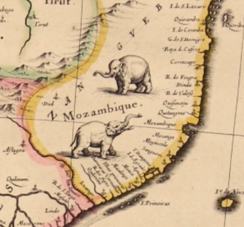
It's also interesting that even though there was little European presence in Africa at the time of this map, Africa is still divided into regions, for example, Mozambique--with its wonderful little elephants--clearly has a border. It's not clear what exactly prompted the inclusion of this border.
Finally, aside from the historic interest and value of this map, being a Blau, one of the reasons it ends up on the wish-list is its aesthetic beauty. The cartouche, and this lonely little turtle in the Gulf of Guinea, make it a stunning map for the collection of anyone interested in this part of the world.


What was the purpose of putting animals etc on the maps? What did they add? Was it just aesthetics?
ReplyDeleteSome of it, yes. Some of it was to show animals people would not have seen before, but some of it also comes from what some historians have called a 'fear of vacant space'. The notion that the map has to contain something, anything. It can't be blank. So if they don't know what does there, they fill it in with animals, or made up creatures. See here, for example: http://mappyplace.blogspot.ca/2018/02/canada-makes-its-debut-map-that.html
Delete