Showing posts with label river. Show all posts

Monday, March 19, 2018

1830 Map of Southern Africa

One of my favorite maps--despite my having not yet framed it to display--is my 1830 Malte-Brun map of Southern Africa. This is one of a couple of maps I've bought from the Pageant Print Shop (who, as always, I have no affiliation with) in New York City. It's the kind of map shop I love. The space is packed in every nook and cranny with maps, generally well organized, but still vague enough that you have to search for the treasure you're looking for. The owners have been in the business for a long time and know what they're talking about and the experience shopping there is really pretty great.

Back to the map! There are many interesting features of this map, but my favorite comes down to two words across the middle of the map. Take a look at the picture and see if you can guess them.

1830 Malte-Brun map of Southern Africa showing South Africa, the Cape Colony, the Sahara, Guinea, Madagascar as well as modern day Kenya and Tanzania among other African places and countries.

Can you guess? The words are "unknown regions". What's more thrilling than a map that shows vast areas that are simply unknown? What carries more mystery, mystique, adventure and possibility than blanks on a map?!

Indeed, in my mind, one of the greatest things about this map is the contrast between the areas that have considerable detail and the regions that have basically none. For example, Madagascar is quite well detailed as is the Cape Colony, the nucleus of modern day South Africa, but so much else is lacking.

As one may expect, most of the detail is on the coasts. The seeds of some modern day countries are visible, for example Angola, Congo, Somalia and Abyssinia, which is modern day Ethiopia are on this map. The detail about some of the various peoples and their regions is also fascinating, and I think would be even more interesting if one knew more about African history than I do.

1830 Malte-Brun map of Southern Africa showing South Africa, the Cape Colony, the Sahara, Guinea, Madagascar as well as modern day Kenya and Tanzania among other African places and countries.


I do know enough, however, to know that the Sudan or "Soodan" on this map, does not stretch all the way across Africa and that Guinea is a relatively small country located on the West coast of Africa, not a large region to the north of the Gulf of Guinea. Benin does seem to be in about the right place though. I also know enough to point out that one of the most well known groups in Africa, the Zulu, who had a burgeoning empire at the time this map was made, seem to be nowhere to be found.

Even the very little detail that does exist in the regions marked as unknown seems incorrect or incomplete, which is really no surprise. For example, compare the length of the Congo River, and it's connection to other major rivers in the region to the relatively puny depiction it gets in this map.

a google maps image of the congo river with it's full length pointed out and highlighted.
The Congo River and rivers it connects with
The map itself does not have original color, but was hand colored by someone after publication. My copy also has a couple of minor stains on it, which diminish its value slightly, but as far as I'm concerned, it's a gorgeous, fascinating map with some amazing detail. I can't wait to get it framed and on the wall.

Thursday, March 8, 2018

Wishlist Map: 5 Things About Montreal You Probably Never Knew

Next up on my wishlist: Bellin's Carte de L'Isle De Montreal et de Ses Environs (Map of the Island of Montreal and its Surroundings) from 1744. This map is available for purchase here, from Arader Galleries (who I have no affiliation or relationship with).


It seems typical of Bellin to show geographic features on his map, but to minimize man made elements. According to wikipedia, at the time this map was made, some 22,000 people lived in Montreal, yet the map does not make this obvious.

Here are five awesome facts about Montreal that we can learn from this map that probably all but the most die-hard Montrealers never knew.

1) Lachine was an island: Today Montrealers are familiar with the neighborhood of Lachine and the Lachine canal that borders it. The canal was built to bypass the rapids shown on the map (the "sault"). The Canal, however, was not all a new waterway. Instead, it was an expansion of Lac St. Pierre that was already separating Lachine from the rest of Montreal.

2) Yes, they really called it "La Chine" (China): La Chine, which evolved into the modern Lachine, was originally a derisive nickname. The explorer La Salle believed that China lay just beyond the impassible rapids upstream of Montreal. Of course it didn't, and what he returned to his home in Lachine from his failed efforts to reach China, he and his companions were mockingly called "Chinese".

3) Forts, forts, forts! There were forts all over the island of Montreal. It would be interesting for a real Montreal historian (i.e. not me) to indicate if any of these still exist, but there were lots of them. I see a fort Roland, fort De La Chine, even a fort Pointe Claire: today an important suburb of the city.

4) The island was crisscrossed by streams. This is not obvious in present day Montreal, and some of these have even been filled in. A modern map of the city, especially in the downtown area, shows no sign of some of the waterways on the map in 1744.


Downtown Montreal today. No streams.

5) Windmills. The city was dotted with them, and they help emphasize the rural nature of the city at the time. Windmills would have been an important part of rural life in the 18th century. There are only a handful of these left today, including the one in Pointe Claire. 

Monday, March 5, 2018

Pittsburgh in 1795 and 1876 and Forts!

My wife and I took a great road-trip from Washington D.C. to Pittsburgh where I stopped in at Shaw Galleries for some map shopping. I ended up buying what I think is the only reproduction in my collection, and yet, it's older than some of the originals I have.


This map shows a plan of Pittsburgh, and its fort from 1795. This, map, however, is almost 100 years more recent than the time it depicts. From what I can find, this map was published by Samuel W. Durant in the 1876 "History of Allegheny Co. Pennsylvania". It is a reproduction of the original map, which I'm pretty sure is this one, held in the University of Pittsburgh library's digital collection:


 The original is quite handsome, but the reproduction has a few interesting features. Forts are always fascinating, and this map provides considerable detail on the Fort at Pittsburgh. Today not much is left of the original fortification built by the British (on the site of an earlier French fort.)


In showing this fort the map almost reveals a kind of self-awareness, that is to say that the map-maker knew that his was a new vision of the city, but that there was a long history before him. The inset shows not only where the previous French fort had been, but also the site of a much smaller frontier fort (itself shown in another inset), but it also shows where roads have since been built passing through and over the site of an important historic feature that no longer exists.

The map also shows a number of Islands in the rivers around the city, including this one with the (in my opinion) charming notation "buckwheat grown in 1795". I note that this remark also seems to appear on the original 1795 map.


I notice, however, that this map shows a number of islands that seem to no longer exist. This well researched piece explains what happened to the islands, which was in most cases erosion. It makes the map even more wonderful as it shows not only man-made change and development over time but also natural changes to the geographic features of the area. Sure enough, a glance at a modern map of the same area shows no islands in the river at all; just bridges, lots and lots of bridges.


Monday, February 19, 2018

Montreal: A Not-So-Old Map of My Hometown and Best City Around!

This 1906 map of Montreal from the Department of the Interior Atlas of Canada is not the most interesting or beautiful to look at, and yet there are so many wonderful things about it. A clearer image may be found here (incidentally, from the same vendor who I think sold it to me).


The source of this map is unique. It's from 1906 and appeared in the first edition of the Atlas of Canada. According to the Canadian government department that still publishes it, that atlas was notable for its emphasis on means of communication and transportation in Canada. 


This is clear from the map. First, the map focuses on the port of Montreal. It's true the city was not as big then as it is now, but the port is impossible to miss. Second, the map notes "street railways" an early form of public transit in the city which is now long gone. Third, larger rail lines are also prominent, including, the famous Grand Trunk Railway, which had its headquarter's in Montreal and was an important rail-line for the country. The Lachine Canal is hard to miss too. Finally, there's the well known Victoria Bridge, shown on the map with a different name.


The bridge shown on this map also alludes to the many changes the city has undergone. For example, today, this view of Montreal would show at least two more bridges from the island, including the now heavily traveled and practically indispensable Jacques Cartier Bridge.

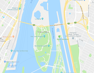
Something else pops up from looking at a current map of Montreal: there are more islands in the St. Lawrence River! "St. Helen Island" and "Ile Ronde" are merged into a single island and there's another landmass just to the east of that. These were all build in preparation for the World's Fair held in Montreal in 1967: Expo '67. The earth dug up in the construction of the Montreal Metro (subway) system was used to expand these islands where the pavilions were based. The U.S. exhibit, Buckminster Fuller's geodesic dome is still on this island. So is La Ronde, an amusement park that takes its name from the once small island that sat alone in the river.

Montrealers will recognize many familiar landmarks on this map, even if they are not named. For example, McGill university is where you would expect to see it, as is the unnamed Royal Victoria Hospital. The train station is also right where you'd expect it.

I had this map framed by an excellent framer, and we discussed where to put the matting. Someone present suggested that the matting should go right to the border of the map, showing only the view of the city and not the plain black line forming the border at the edge. The framer made a comment that has since stuck with me: the cartographer decided that they wanted to only show this part of the city, and nothing else. They chose that location for the border, and to hide it, would be detracting from the historic significance of the document. It reminded me that these maps are bits of history, and to have them, and show them comes with the obligation of being faithful to their purpose and message.


Tuesday, February 6, 2018

The Wild West: Johnson's Washington and Oregon of 1861

On a trip through the U.S. Pacific northwest, I bought this example of Johnson's Washington and Oregon from 1861.


I wasn't able to get a great image of it because it's framed, but there's a great 'zoomable' photo of the same map here.

I originally bought this map because it was the best one I could find of the region while in the region. I found it quite attractive and interesting, but perhaps a bit plain. The more I study it though, the more I've come to like it.

 The map does have some nice aesthetic features, for example the decorative border, the map spilling out of its border and the textured way in which the mountains are drawn. It also has that somehow strange feature of showing not only the longitude from Greenwich, but also from Washington, D.C.

The map has quite a bit of space with little on it other than lakes, rivers, mountains and the occasional fort. It gives a sense that this is a frontier region. It makes the area on the map feel more vast, more difficult to access and it makes the west coast, which does have more towns indicated, seem like more of a goal to reach. As though it's a slice of civilization across a land-sea of tough wilderness. This is somehow also enhanced by showing a proposed route for a railway line.


More interesting than some of the aesthetic features of the map, I find, are the political elements, and the elements of the map that did not exist in 1861 but that today would not only be present, but would be prominent.

The most obvious is the shape and existence of states and territories. Washington sort of wraps around and embraces Oregon. Idaho is just not there, and instead, Washington borders the Nebraska Territory. Montana is a figment of someone's imagination and is not on this map.

To the south of Oregon, the map does depict California, which borders the Utah Territory and all throughout over areas of otherwise blank map, we see the names of first nations tribes that lived in that territory. Prominent are "Shoshones or Snakes", "Punashly" and "Nez Perces".

Of particular interest to me are the areas that are now Canada, marked only as "British Possessions". This is not meant to be a map of Canada or the British possessions to the north, but there are still some great details there. The blanket label "British Possessions" is alone an interesting historical element. These regions would not even become part of Canada 6 years later during Confederation. They joined the country much later. Another detail I like is that, though there is a Seattle, and a Victoria (now British Columbia) on the map, there is no Vancouver. This is because what is now one of Canada's largest and most prominent cities was not settled until 1862, the year after this map was published.


One more detail about this map that I personally like is the absence of the town of Great Falls, Montana. I've never been to Great Falls, but my late grandmother spent some of her childhood there, and spoke about it fondly. This map shows only that there are falls at the site (just below the "e" in territory of the "Nebraska Territory"), but there's no settlement. The city where my grandmother watched the celebrations for the end of World War One, was not founded until the early 1880's.