The source of this map is unique. It's from 1906 and appeared in the first edition of the Atlas of Canada. According to the Canadian government department that still publishes it, that atlas was notable for its emphasis on means of communication and transportation in Canada.
This is clear from the map. First, the map focuses on the port of Montreal. It's true the city was not as big then as it is now, but the port is impossible to miss. Second, the map notes "street railways" an early form of public transit in the city which is now long gone. Third, larger rail lines are also prominent, including, the famous Grand Trunk Railway, which had its headquarter's in Montreal and was an important rail-line for the country. The Lachine Canal is hard to miss too. Finally, there's the well known Victoria Bridge, shown on the map with a different name.
The bridge shown on this map also alludes to the many changes the city has undergone. For example, today, this view of Montreal would show at least two more bridges from the island, including the now heavily traveled and practically indispensable Jacques Cartier Bridge.
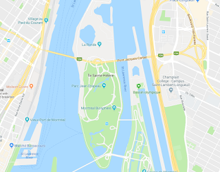
 Something else pops up from looking at a current map of Montreal: there are more islands in the St. Lawrence River! "St. Helen Island" and "Ile Ronde" are merged into a single island and there's another landmass just to the east of that. These were all build in preparation for the World's Fair held in Montreal in 1967: Expo '67. The earth dug up in the construction of the Montreal Metro (subway) system was used to expand these islands where the pavilions were based. The U.S. exhibit, Buckminster Fuller's geodesic dome is still on this island. So is La Ronde, an amusement park that takes its name from the once small island that sat alone in the river.
 Montrealers will recognize many familiar landmarks on this map, even if they are not named. For example, McGill university is where you would expect to see it, as is the unnamed Royal Victoria Hospital. The train station is also right where you'd expect it.
I had this map framed by an excellent framer, and we discussed where to put the matting. Someone present suggested that the matting should go right to the border of the map, showing only the view of the city and not the plain black line forming the border at the edge. The framer made a comment that has since stuck with me: the cartographer decided that they wanted to only show this part of the city, and nothing else. They chose that location for the border, and to hide it, would be detracting from the historic significance of the document. It reminded me that these maps are bits of history, and to have them, and show them comes with the obligation of being faithful to their purpose and message.


No comments:
Post a Comment