Showing posts with label archaeology. Show all posts

Wednesday, April 4, 2018

15th Century Viking Map of Vinland Being Studied by Yale

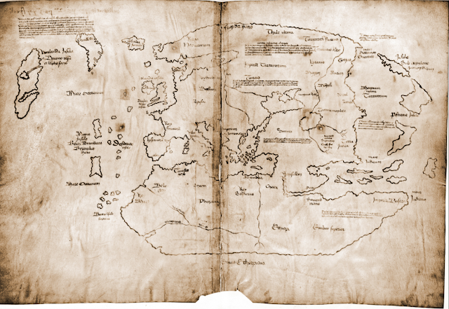
I recently came across this article about Yale doing an examination of the Vinland Viking map. I had heard about Vinland, but don't recall having heard about this map before. In short, Vinland is an as yet undiscovered location supposedly settled, at least briefly, by the Vikings in the 15th Century, before Columbus reached the New World. This map, which would have been almost as old as the Viking discovery, showed Vinland.

Here is an image of it from Wikipedia.

The probably forged Map of the Viking discovery of Vinland in the possession of Yale University

It's a pretty cool map, and very exciting to have so old a map of the new world. The problem is, it's almost universally considered to be a fake. There is some disagreement on this, but the majority of scholars have dismissed this map as being inauthentic for a number of reasons including the chemical composition of the ink used (it contains substances unused until the 1900s) and the way it was bound into a larger manuscript which would have rendered much of it illegible.

Nonetheless, Yale is putting some serious work into researching this map. They are looking at the topography of the map itself, studying the DNA of the animal skin it was printed on, and examining the maps's chemical composition. It's all very impressive, and still, they don't expect to prove its authenticity. Instead, they're trying to study a document which has become so culturally important, that many atlases feature it even with the notation that it's probably fake.

So then, what is Vinland? The answer is that nobody's quite sure. There are disagreements among experts as to what the word Vinland meant to the Vikings and whether it was a single place, or multiple places. If Vinland does refer to vines, or wine, as some suggest, it means that it must be at least as far south as the south shore of the St. Laurence River, where Jacques Cartier found wild vines. One thing that does seem more certain is that the only actual archaeological evidence of Viking settlement in North America, the site at L'Anse aux Meadows, Newfoundland, is not Vinland.

Map of L'Anse aux Meadows, NewfoundlandL'Anse aux Meadows is a remote site at the northernmost point of Newfoundland. Viking artifacts have been found there, as well as building materials from Iceland and Greenland that date to around 1000 C.E. This is conclusive evidence that there were Vikings living in Newfoundland, for at least a short time,  around 500 years before Columbus and any other European reached the area. The site, however, is considered by historians to be a base, or a waypoint for onward exploration. It was probably just a place to stop, maybe repair boats, take on more supplies, and then keep exploring onward. As such, the location of Vinland remains a mystery, and this map will likely not be helpful in finding it.

As an aside, I had the good luck of visiting L'Anse aux Meadows, which is not an easy place to get to, but which is stunningly beautiful and worth the trip. It also has a reconstruction of what the Viking settlement on the spot may have looked like. It's a long trip, but in my view, absolutely worth it. Check out some pictures I took while there.

UNESCO heritage plaque indicating Vikings were at this site.

L'Anse aux Meadows, Newfoundland

Site of a Viking building. The indentations on the ground show the footprint of the long since decayed building.
This depression was the actual site of a Viking structure.

A recreated Viking settlement on the site of the only known one in North America.

A recreated Viking settlement


Fog rolling into L'Anse aux Meadows, Newfoundland

Fog rolling in to L'Anse aux Meadows, Newfoundland


Thursday, January 11, 2018

Exceedingly Rare Aztec Map

Thanks to National Geographic, I came across this story about a map that is as much archaeology as it is geography.

The map is called thCodex Quetzalecatzin, was recently acquired by the U.S. Library of congress and is one of fewer than 100 Mezoamerican maps that predate the year 1600. In other words, it's an extremely rare, Aztec map from sometime between 1570 and 1595. 


Image of the Codex Quetzalecatzin frm the U.S. Library of Congress
The map shows the family tree and land holdings of an Aztec family and "...covers an area that runs from just north of Mexico City to just below Puebla, roughly 100 miles away to the southeast"

It contains both Aztec imagery as well as clear Spanish influences, not least the Spanish writing on the map. It appears to represent some of the earliest contact between the indigenous people of Mexico and Europeans. 

From looking at it, what strikes me is that it barely looks like a map at all. It looks more like a drawing of a landscape, or what we may call a "view", than a map. To the layperson like me, it also seems to have a strange scale and it is not immediately clear that it represents such a vast area. 

It is beautiful though, with vibrant colours and images such as this snippet: 


The U.S. Library of Congress has at least one other map like the Codex Quetzalecatzin. It's called the The Oztoticpac lands map, and though it has no doubt been the subject of extensive study, I cannot find very much about it online.


This one is even older than the Codex Quetzalecatzin and dates to around 1540. It's described as a "litigation map", relating to a property dispute. Some detail on it from The Library of Congress reads:

 The Oztoticpac Lands Map is an Aztec pictorial document with Nahuatl writing drawn for a court case surrounding the Oztoticpac estate within the city of Texcoco around 1540. The document, written on amatl paper, involves the land ownership of the Aztec ruler Chichimecatecotl, who was executed by Spanish officials in 1539. It is not clear from surviving information who won the case. Most of the document consists of black-and-red line drawings showing fields, houses, palaces, trees, and measured plots of land. In the lower left, twenty trees that have been grafted with European fruit stock in a local orchard are shown. These include apples, quinces, pears, grapes, and pomegranates.

Here's an image with a better look:

There are some fascinating details on this map, some of which probably require a better historical and cultural knowledge to understand, but which to the layperson, are interesting and fun to look at.

For example, the map contains images of various plants. The quote above explains what they are, but some of the images are so curious. For example, in the image of the plant below, whose disembodied hands are those, and why are they there at all? Whose disembodied heads are these and, what's this man doing all alone on this plot of land? These seem to be more than just decorative, and when considering that this map was used in a court case, one has to imagine that they are meant to reflect a certain ownership of a particular area shown on the map.


One reason I love antique maps is because they represent a snapshot of what a place was like at a specific moment in time. These maps do that, and then some. There are not just about what places looked like, but they tell us about who lived there and how they lived. This is more than you would get from your average antique map. It's why, as I wrote above, that maps like this fall into the category of archaeology. They help us understand how people who are long gone structured their lives and societies. They're windows into history and a pleasure to look at.