Showing posts with label fake. Show all posts

Wednesday, April 4, 2018

15th Century Viking Map of Vinland Being Studied by Yale

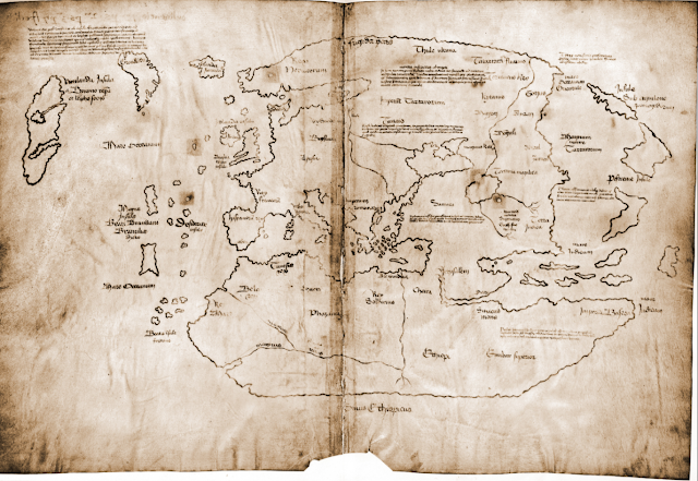
I recently came across this article about Yale doing an examination of the Vinland Viking map. I had heard about Vinland, but don't recall having heard about this map before. In short, Vinland is an as yet undiscovered location supposedly settled, at least briefly, by the Vikings in the 15th Century, before Columbus reached the New World. This map, which would have been almost as old as the Viking discovery, showed Vinland.

Here is an image of it from Wikipedia.

The probably forged Map of the Viking discovery of Vinland in the possession of Yale University

It's a pretty cool map, and very exciting to have so old a map of the new world. The problem is, it's almost universally considered to be a fake. There is some disagreement on this, but the majority of scholars have dismissed this map as being inauthentic for a number of reasons including the chemical composition of the ink used (it contains substances unused until the 1900s) and the way it was bound into a larger manuscript which would have rendered much of it illegible.

Nonetheless, Yale is putting some serious work into researching this map. They are looking at the topography of the map itself, studying the DNA of the animal skin it was printed on, and examining the maps's chemical composition. It's all very impressive, and still, they don't expect to prove its authenticity. Instead, they're trying to study a document which has become so culturally important, that many atlases feature it even with the notation that it's probably fake.

So then, what is Vinland? The answer is that nobody's quite sure. There are disagreements among experts as to what the word Vinland meant to the Vikings and whether it was a single place, or multiple places. If Vinland does refer to vines, or wine, as some suggest, it means that it must be at least as far south as the south shore of the St. Laurence River, where Jacques Cartier found wild vines. One thing that does seem more certain is that the only actual archaeological evidence of Viking settlement in North America, the site at L'Anse aux Meadows, Newfoundland, is not Vinland.

Map of L'Anse aux Meadows, NewfoundlandL'Anse aux Meadows is a remote site at the northernmost point of Newfoundland. Viking artifacts have been found there, as well as building materials from Iceland and Greenland that date to around 1000 C.E. This is conclusive evidence that there were Vikings living in Newfoundland, for at least a short time,  around 500 years before Columbus and any other European reached the area. The site, however, is considered by historians to be a base, or a waypoint for onward exploration. It was probably just a place to stop, maybe repair boats, take on more supplies, and then keep exploring onward. As such, the location of Vinland remains a mystery, and this map will likely not be helpful in finding it.

As an aside, I had the good luck of visiting L'Anse aux Meadows, which is not an easy place to get to, but which is stunningly beautiful and worth the trip. It also has a reconstruction of what the Viking settlement on the spot may have looked like. It's a long trip, but in my view, absolutely worth it. Check out some pictures I took while there.

UNESCO heritage plaque indicating Vikings were at this site.

L'Anse aux Meadows, Newfoundland

Site of a Viking building. The indentations on the ground show the footprint of the long since decayed building.
This depression was the actual site of a Viking structure.

A recreated Viking settlement on the site of the only known one in North America.

A recreated Viking settlement


Fog rolling into L'Anse aux Meadows, Newfoundland

Fog rolling in to L'Anse aux Meadows, Newfoundland


Monday, February 5, 2018

Caveat Emptor: The Lesson of the Fake Waldseemüller Gores

There have been stories recently, in major news publications, about an extremely rare, early 16th century map that was set to go to auction with an expected selling price of at least USD800,000, but that has turned out to be a fake. It's a cool story, and a cautionary tale worth recording.

The map in question is the Martin Waldseemüller "gores". Gores are meant to be cut out and pasted onto a sphere to create a globe. That's one reason why this map is so rare. Most of these maps would have been cut up after being produced and lost over time. In fact, only four originals were known to exist of a map believed to be the first printed globe and the first to use the word "America".

The map was described as "a huge deal". It was the first to show the world in 360 degrees. Showed an important new landmass, and introduced an important new word into our lexicon. It also gave arguably inflated importance to the explorer Amerigo Vespucci.

It's an amazing thought, that just 15 years after Columbus's voyage, a map-maker scrambled to compile all this new information he's learning about the new world and to try and express it in a new way.  

Apparently, the story goes that someone walked off the street into Christie's auction house and claimed to be a descendant of a well known British paper restorer who had found the map among his late-relative's papers. The experts at the Auction house were overjoyed. The felt they had chanced upon an amazing treasure. Too bad they were wrong.


A map expert named Alex Clausen, employed by the well known (in the map world) Barry Ruderman of Barry Lawrence Ruderman Antique Maps, spotted a few things amiss.

A drop of glue on the paper, that would have affixed it to something, had print on top of the adhesive, rather than under it, as might be expected. In other places, detail seems to have been added to the map, where it would have been expected to be missing as the printing process wore it down. Another concern, caught by another paper expert, was that there was a line on the map that matched a spot where a verified original map had been repaired. It was too coincidental for this new map to have an identical repair. Moreover, another copy of the map, previously presumed to be original also had this same line. That latter map's status as an original is now also being re-considered by its owner.

Such a map would likely never be in the hands of an amateur or casual map collector, but it raises a question: if most experts were nearly fooled, how could an amateur ever avoid being duped? If the nuances between the real thing and a fake are so hard to detect, it's discouraging to someone who may want to take a step into buying some of the rarer, older, and more expensive maps that are on the market. The best advice, is probably to ask lots of questions of the seller, including about the provenance--the historical chain of ownership--of the map. It also helps to have a high level of trust in the seller.

Above all, it reinforces the much older maxim: caveat emptor! Let the buyer beware.

Monday, January 8, 2018

My Mystery Map: Istanbul

The second map I ever bought was in Istanbul, but it's the map I know the least about, and the more I read and hear about it, the more I'm convinced that it's more of a pretty work of art than it is an actual antique map. In fact, after extensive searching, I can't find anything that even looks like it online.

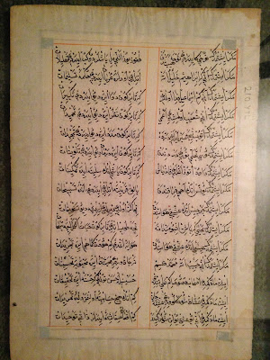
When buying the map, I faced a real language barrier, but it was from what appeared to be a reputable shop that had a small number of other, somewhat similar maps. What I understood from the strained conversation was that this was a page from an antique Ottoman atlas showing a map of Istanbul. I'm pretty sure now that this was not correct. Take a look and I'll try to break it down.


So above is the front of the map I bought and to the right is the reverse of the page. This map is framed and hanging on my wall, so I can't handle it, but my recollection was that the paper seemed authentic, or at the very least, not modern. Also, I cannot read the writing on this map, but it seems clear to me that it was not printed and was probably done by hand. I believe that it's the Ottoman Turkish Alphabet, which borrows from Arabic and Persian.

There are some clues about the map, but I have a hard time deciphering them. For example, I can't figure out who the hirsute chap in the photo is. I would guess he's supposed to be an Ottoman Sultan, but maybe he's a governor of the city, or some other important person.

There's also the banner at the top-center of the page. From what I can tell from searching here, it looks like an Ottoman banner that may have been used in the 18th century, but this is anything but certain.


Then there's the cityscape itself. I'm not sure what vantage this view was taken from. As best as I can tell from playing around with google streets view from Istanbul, this image is meant to be taken from the Bospherous, looking south from Galata. Somewhere around the area marked in blue.


This brings me up against a few problems. The mosque on the right hand side has three minarets and the one on the left has four. I'm pretty sure, just from the drawing, that the mosque with three minarets is meant to be the Hagia Sophia. That's simply what it looks like. The problem is, the actual Hagia Sophia has four minarets. The other mosque, which is blue in colour, could be meant to be the Blue Mosque, but that one has six minarets. Even playing around on google streets view, I can't figure out what possible vantage point would give the viewer a sight of two mosques, on on the right with three minarets and one nearby on the left with four.


I brought this map for an informal appraisal to a shop in Washington, D.C. where I used to live. The appraiser agreed that the paper it was on was old, and was less concerned than I was that the colours of the map were too vibrant to be old. Her view, however, was that the drawings themselves looked modern, that they do not reflect the way something may have been drawn long ago and that the painting of the map was probably quite new. She may be on to something. A close look at the map (not something I can show in a photo) reveals that there is text behind it, in the same script as the text on the reverse.

I'd love to know more about this map if there are any knowledgeable or sleuthy people out there who can help (or anyone who can read the Turkish).

In the meantime, despite it probably not actually being an antique map, it's still a beautiful bit of work and I'll happily keep it on my wall.