Showing posts with label 17th century. Show all posts

Monday, July 30, 2018

A Gift to Canada Speed's 1662 Map of the Americas

Library and Archives Canada recently tweeted this:
It's a link to a fascinating map of the Americas from 1662. The link in the tweet above brings you to an image of the map which can be zoomed in on, to a point. The image is here:


 The map is fascinating. The known regions are packed with detail and there are place names that strike the modern viewer as strange. For example, Bermuda is listed as "now called the Summer Isles" and the south-west United States is listed as "New Granada".

The map also has such geographic oddities, such as the island of California, the connection between Greenland and the mainland of the continent, and the strange shape of Hudson's Bay, to name a few. The map also has, what seems to me, to be a strange omission. Though the map notes the location of "Canada" there is no mention of "New France". Perhaps that name was not commonly used, but there's nothing to even indicate that Canada was a French possession.

The map itself has some beautiful detail. The top of the border has miniature plans of important cities such as Mexico and Cartagena.


The sides of the map are bordered by miniatures of native peoples of the various places shown on the map. See, for example, this Greenlander and Virginian.

Doing a bit of digging, I came across this website that provides a bit more information on this map. It seems that even though this map (and others in the Atlas) is attributed to Speed, as the cartographer, this is apparently actually a Dutch map that Speed simply "anglicized". Indeed, the style of including miniatures in the border is a Dutch invention known as "cartes à figures". This copying may explain why many of the miniature city plans at the top of the map are not of English colonies, despite this map appearing in an English atlas.

The map is quite beautiful and interesting. I'm not sure if the national archives would allow the public to view it, but it's an important piece of history that shows a snapshot of Canada from around 350 years ago. It's a marvelous piece. Oh, and it has sea monsters!




Monday, June 4, 2018

The Map That Got Away: A 1632 French Map of Madeira, Portugal

Recently, I was in Funchal, on the Island of Madeira, Portugal, for work. I had limited free time, but hoped to buy a map of the place if I could find one. The bit of research I did was unable to give me any clues on where I may be able to find an antique map of the place, so on a whim, I stopped in at a shop catering to coin and stamp collectors to see if they may be able to help point me in the right direction.

The owner of the shop didn't have any encouraging news for me, but I noticed, on the wall in a corner of his shop, he did have a couple of maps, one appeared to be a Bellin. When I told him I wanted a local map, he went round to the back and after a few minutes, produced this.


I was pretty excited. It was listed as selling for 170 Euro, but the man in the shop told me he'd accept less if I paid cash (which I didn't have on me in any case).

I asked him if I could take a closer look at the map, which was in matting, and that's when the red flags started popping up. The map did look authentic and original. It was very clean, but the grain of the paper seemed authentic, there was no colour and it seemed right.

When I wanted to see the reverse, however, I realized that it was glued to the backing. That worried me. The owner, to my horror, started trying to pull the map loose from the glue. I was terrified it would tear. It didn't, but he was able to peel enough of it away that I could see a date on it, 1632.

Knowing that I couldn't buy it at that moment anyway, I went back to work and resolved to research it a bit. I came up empty handed. I couldn't find an image of this map, or even one similar to it anywhere. I knew it was probably French, had an approximate year but knew nothing more. So, I turned to twitter.


It took some time, but I got a few helping hands from the twitterverse, and one, particularly helpful reply from the very helpful New York Public Library Map Division. I have no idea how they did this, but they found the origin of this map.


Incredible! They were right! There it was, on page 215 of the microfilm was the map from the store. It even confirmed another concern I had, that there was nothing printed on the reverse of this map. That's because it was on the last page of a chapter in an atlas, and page 216 was blank with a new section beginning on page 217.

My next concern, however, was the glue. My concerns were confirmed by NYPL Maps and also James Roy, who wrote:


I was aware of all these concerns, but I thought, I like the map enough, that even if there are some concerns with it, if I can get it for a good price, it will be worth it.

It's a great looking piece, the ships, the perspective, the way the towns are drawn and the age of the map itself were all so appealing I couldn't believe my luck to have found it.

The problem was, the store had limited hours and I was extremely busy with work. I sent the owner an e-mail to see if I could convince him to stay open a bit longer, or to meet me on a day when he was closed, but the e-mail bounced back. Alas, I had to leave the island without a map.

So, I may have been saved by circumstances from buying a forgery or a map whose quality was greatly compromised by glue. I also learned there are some people out there on twitter who really know their maps and are very generous with their time and information. Still though, I can't help but feel that this one got away from me. I guess I will need to add a map of Madeira to my virtual wish-list!

Thursday, April 19, 2018

Add it to the Wishlist: Blau's 1635 Map of South Africa “Aethiopia Inferior, vel Exterior“

I recently wrote about my 1830 map of southern Africa. One reason I found that map so interesting, was that it showed an Africa which had tribes in it, but very few European powers were setting up colonies in that part of the world.

This map of Southern Africa from 1635 is on sale by Inter-Antiquariaat Mefferdt & De Jonge in the Netherlands (as always, no affiliation). Take a look:

1635 map of south africa by blau. Shows southern africa before the dutch colonized it.

The sellers of this map have some good information about it on their website. They note a few interesting points. For starters, this map pre-dates Dutch colonies in this part of the world. It also notes that much of this map is based off of Portuguese maps, which are of mixed-degrees of accuracy.

The map does a pretty good job showing off various coastal place names, but these seem to be the names of geographic features (i.e. bays, coves, etc). There are also a few towns shown in the interior, but like the 1830 map of the same region, this map does not try to pretend to know what lies just beyond the coast.

a close up view of the cape of good hope, caffaria, or kaffraria, and an illustrated sailing ship.

Also notable is the lack of names of tribes found on the 1830 map. It may be that Europeans were not sufficiently familiar with the inhabitants of Africa to name them. Part of South Africa on this map is named "Caffaria", or Kaffraria, which is a word that has at its root a derogatory term for Africans. The name of this place appears on the 1830s map as well, and so it seems that Europeans were either indifferent to the disrespectful use of the word, or that it only fell out of accepted usage at a later date.

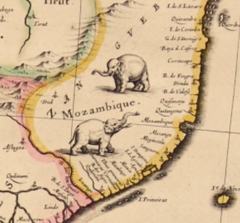
It's also interesting that even though there was little European presence in Africa at the time of this map, Africa is still divided into regions, for example, Mozambique--with its wonderful little elephants--clearly has a border. It's not clear what exactly prompted the inclusion of this border.

close-up of Mozambique with illustrated elephants.

Finally, aside from the historic interest and value of this map, being a Blau, one of the reasons it ends up on the wish-list is its aesthetic beauty. The cartouche, and this lonely little turtle in the Gulf of Guinea, make it a stunning map for the collection of anyone interested in this part of the world.

Cartouche of the map showing Africans holding an ox hide with monkeys and turtles

Turtle illustration.