Showing posts with label Jerusalem. Show all posts

Monday, February 26, 2018

The Land of Moriah, or Jerusalem

What place in the world has more meaning to people, or more historical significance than Jerusalem?

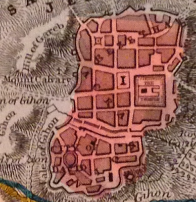
I bought this map of Jerusalem at M. Pollak's map store in Tel Aviv. I really like this one and was very excited to buy it.


The map is titled "Land of Moriah or Environs of Jerusalem". The map maker is Thomas Starling, and printed at the bottom is "London, Published for the proprietors. by Mr. Bull, Holles Street Cavendish Square". An inscription on the back from the seller indicates that the original date of publication was 1836. This date, however, does not appear on the map itself.


That's about all I know about the map. Research shows that Starling published a few atlases, including some in the U.S., but I can't figure out which one this would be from.

What I can point out are some of the really unique features of this map, starting with the name, Land of Moriah. The name alone is controversial as it's a biblical name about which scholars disagree. Some say that it refers only to the site in Jerusalem where the Temple of Solomon stood, while others say it may refer to a region, as shown on this map. There are differences based on religious belief as well.

The map is interesting as it shows how the land would have been divided between at least two of the 12 tribes of Israel, here, Judah is in the south and Benjamin in the north. It also has a great little plan of old Jerusalem with certain important sites pointed out.

To really get an appreciation for some of the more interesting details on this small map, one needs to look much more closely.

For example, there's a tiny cross on the Mount Calvary. A structure is simply identified as "the temple" and "the City of David" all appear in the small plan of Jerusalem.


The map also notes the site of at least two biblical battles between the Israelites and the Ammonites and the Philistines.


Bethlehem, and the road between it and Jerusalem are shown on the map, alongside "David's Cistern" and "Solomon's Fountains". All of these, are, of course, biblical sites.

There is also reference to sites of "idol worship" and a number of other specific places found in biblical reference.

This is a small, but attractive map that is meant to show not only a biblical history, but may also reflect an interest in such matters at the time. The effort that went into making such a map, must have some positive correlation to the contemporary demand for such a product.

I only wish I knew a bit more about this map and its origins, and I welcome insights from those who know more about this publisher and this cartographer than I do.

Monday, January 29, 2018

Missing Pieces: Mitchell's 1867 Washington, D.C.

For the few years I lived in Washington, D.C., anytime I found myself in Georgetown, I would make a point of trying to stop in at the Old Print Gallery. This was a unique shop. It didn't have that dusty, feeling of some map shops that I love, but instead was clean, sleek and modern feeling. It had row upon row of cases of maps and prints arranged by location, alphabetically, and it had some true


gems, like Bunting's Cloverleaf of the world with Jerusalem at the center.

They also had a beautiful original of the first plans for the city of Washington, D.C. in 1792 by Andrew Ellicott. It was being sold for over US$40,000. Living in Washington, I knew I wanted a map of the city, and the Ellicott was truly the pinnacle of all such maps, but for me, at that price, it may as well have been one million dollars. It was unobtainable.


This image is in far worse condition than the one at the Old Print Gallery


I no longer live in Washington, but I'm disappointed to learn that the shop has closed, and merged with it's sister shop in New York City. It's a shame, because it was such a wonderful place, and I don't know of any other shops in D.C. that were as specialized.

The price of the Ellicott map being what it was, I turned to the internet to find myself a nice map of D.C. to add to my collection and came across a shop in Vancouver, British Columbia called Joyce Williams Gallery who had a great selection and very fair prices.

After speaking and corresponding with their friendly owner, I settled on this beautiful, very fine 1867 Augustus Mitchell Jr. map of Washington, D.C.


There's a lot to love about this map. Its wonderful to look at. It has an attractive floral border that somehow just pops out, without taking away from the map itself.

It also shows a number of details which may have been common for the time, but that today we would recognize as archaic, or simply unusual. For example, the White House is referred to on the map as the "President's House", This is a use that may be considered even more unusual because, as wikipedia notes, the place was called the White House as early as 1811, some 56 years before this map was published.

Another wonderful thing about this map is what it doesn't show. Some of the things tourists flock to D.C. for are absent altogether. For example, the Smithsonian is shown on the map, but only one building, not the many large facilities that make up its network. The Library of Congress is not on the map, as it would not be built for another 30 or so years. There's no reflecting pool either, and one may notice that the National Mall is not at its full length.


Most stark, perhaps, was something that actually did not jump at me right away: There's no tidal basin! The famous cherry blossom ringed body of water, the site of the Jefferson Memorial, just did not exist at the time this map was made. I looked at this map for quite some time before I even noticed that! Indeed, apparently, the idea for the basin didn't even originate until the 1880's, almost 15 years after this map.


The Mitchell map certainly lacks the historic value of the Ellicott, but it's a gorgeous piece, and one that I'm very pleased to have in my collection.